

SPACE TECHNOLOGY – BASIC CONCEPTS
Space technology includes **tools, machines, and systems** used to explore space and study Earth from space. It covers satellites, launch vehicles, rockets, space probes, telescopes, and related technologies used for communication, navigation, and scientific discovery.
Space technology helps monitor weather, manage disasters, support communication, and improve navigation. It boosts **national security, scientific research, and economic growth**.
India uses space systems for **rural connectivity, crop assessment, ocean studies**, and climate monitoring, making it crucial for national development.
A satellite is an object placed in **orbit** around Earth or another celestial body. It can be natural, like the Moon, or artificial, like INSAT. Artificial satellites support **communication, broadcasting, mapping, and scientific data collection** from space.
Communication satellites relay signals; navigation satellites provide location; remote-sensing satellites capture Earth images; and scientific satellites study space phenomena.
Each type is designed for a specific purpose but often supports **multiple tasks** through onboard instruments, providing versatility to space missions.
Orbits are **fixed paths** around Earth. Common ones include **Low Earth Orbit (LEO)** for imaging, **Medium Earth Orbit (MEO)** for navigation, and **Geostationary Orbit (GEO)** for communication. Orbits decide coverage area, resolution, and mission lifespan.
Every satellite has two parts. The **payload** performs the mission, such as cameras or sensors, gathering the critical data or relaying signals.
The **bus** supports the payload by providing power, communication links, temperature control, and structural stability throughout the mission life.
Launch vehicles are **rockets that carry satellites to space**. They use multiple stages filled with fuel to escape Earth’s gravity. India’s **PSLV** is ideal for remote-sensing satellites, while **GSLV** launches heavier communication satellites to higher orbits.
Remote sensing observes Earth **without direct contact** using sensors on satellites. These sensors record **reflected sunlight or emitted radiation** from the Earth's surface.
The data helps track **forests, water bodies, urban growth**, and monitor **disasters** such as floods or cyclones, aiding in environmental management.
Navigation satellites provide **precise location and timing**. India’s **NAVIC** offers regional navigation services. Navigation is crucial for **transport, disaster response, agriculture mapping**, and synchronizing banking and telecom networks across the country.
Space technology supports **weather forecasting, TV broadcasting, mobile networks, GPS navigation**, crop planning, and ocean studies.
Even basic services like **ATMs, aircraft routes, and shipping lanes** rely heavily on satellite-based timing and communication systems for daily operations.
India’s Leap: The Space Tech Story
Founding Philosophy (Early 1960s)
India’s space journey began in the early 1960s under the leadership of **Dr. Vikram Sarabhai**. He believed space technology must directly support **national development**—weather, agriculture, communication, and education—rather than prestige or power.
Thumba: The Launch Pad
**Thumba**, a coastal village near Thiruvananthapuram, was selected for rocket research because it lies close to the **Earth’s magnetic equator**. This location allows accurate study of the upper atmosphere—essential for early scientific experiments.
Community Cooperation
When officials approached villagers for land, the locals **cooperated** despite losing homes and fields. The Catholic Church, schools, and surrounding land were peacefully handed over. This mass **voluntary support** became symbolic of India’s collective scientific aspiration.
St. Mary Magdalene Church: First Office
The small **St. Mary Magdalene Church** at Thumba served as the first office of the Indian space programme. The church hall became the design room, the bishop’s room became the office for Sarabhai, and the nearby sheds became workshops.
First Rocket Assembly and ISRO’s Birth
The first sounding rockets were so light that parts were carried by **bicycles and bullock carts**. Despite limited resources, scientists focused on building technical skills from scratch. In **1969**, the **Indian Space Research Organisation (ISRO)** was created to institutionalise space activities, focusing on practical needs like experimental satellites for communication and education.
The Leap into Satellite Technology
ISRO built **Aryabhata** (1975), India’s first satellite, marking a shift from experimental rockets to advanced space engineering. Later missions like **INSAT** and **IRS** provided real benefits—telecom, disaster management, crop monitoring, and weather alerts.
PSLV: India’s Workhorse
The **Polar Satellite Launch Vehicle (PSLV)** became a major technological milestone. Known for **reliability and cost-effectiveness**, it enabled India to launch domestic and foreign satellites, boosting global credibility in the commercial launch market.
Self-Reliance and Developmental Focus
From the humble church office at Thumba to missions like **Chandrayaan, Mangalyaan, and Gaganyaan**, India’s space programme reflects scientific **self-reliance**. It combines **low-cost innovation** with a strong developmental focus—core aspects of India’s space identity.
Development of Launch Vehicles in India
Early Beginnings (1963)
India’s space journey began with **sounding rockets** in 1963 at Thumba. These small scientific rockets helped study the **upper atmosphere** and gave India essential experience in **propulsion, tracking, and launch operations**, forming the base for future vehicle development.
Mastering Solid Propellant Technology
Through the 1970s and early 1980s, India focused on mastering **solid-propellant technology**. This phase saw the development of the **Satellite Launch Vehicle (SLV-3)**, India’s first experimental launcher, which successfully placed the **Rohini satellite** in orbit in 1980.
SLV-3: First Step Toward Autonomy
SLV-3 used a **four-stage solid propulsion system**, demonstrating India’s self-reliance in basic launch vehicle design. Although limited in capacity, it proved critical concepts such as **staging, guidance, and control** for more advanced missions ahead.
Augmented Satellite Launch Vehicle (ASLV)
The **Augmented Satellite Launch Vehicle (ASLV)** aimed to improve payload capacity using **strap-on boosters**. Despite multiple failures, it taught ISRO essential lessons in **vehicle stabilization, vibration control, and mission reliability**, strengthening India’s engineering ecosystem.
Polar Satellite Launch Vehicle (PSLV)
The **Polar Satellite Launch Vehicle (PSLV)**, operational since 1994, revolutionized India’s space reliability. With a mix of **solid and liquid stages**, PSLV gained global reputation for precision, enabling missions like **Chandrayaan-1, Mangalyaan**, and numerous commercial satellite launches.

Geosynchronous Satellite Launch Vehicle (GSLV)
The **Geosynchronous Satellite Launch Vehicle (GSLV)** was developed to place heavy communication satellites into **geostationary orbit**. Its key advancement was the **cryogenic upper stage**—a complex technology that required years of testing, refinement, and indigenous development.
Cryogenic Technology Breakthrough
Mastering **cryogenic engines** (using super-cooled liquid hydrogen and oxygen) marked a technological milestone, providing **higher thrust and efficiency**. India’s indigenous cryogenic engine success in **GSLV-D5 (2014)** significantly boosted deep-space and heavy-lift capacity.
Launch Vehicle Mark-3 (LVM3)
**LVM3**, India’s most powerful launcher, can place **four-tonne class satellites** into geostationary orbit. It also enabled the human-spaceflight program, serving as the launch vehicle for the upcoming **Gaganyaan mission** and demonstrating India’s matured capability.
Reducing Costs with RLV-TD
ISRO is testing **reusable launch systems** to reduce costs. The **RLV-TD** missions demonstrated autonomous landing and hypersonic flight. Reusability is expected to enhance India’s long-term **competitiveness** in the global launch market.
Future Pathways and Private Sector Role
India’s new space policy encourages **private launch vehicles**, such as Skyroot’s Vikram series and Agnikul’s Agnibaan. ISRO is also exploring semi-cryogenic engines, heavy-lift concepts, and sustainable access to space, shaping the **next generation** of launch systems.
Development of Space Engines in India
India’s **space engine development** reflects decades of steady technological advancement under **ISRO**. From early liquid engines to advanced cryogenic and air-breathing systems, these engines power India’s satellites, launch vehicles, and future reusable space missions.
Engine Type & Composition
The **Vikas engine** is a liquid-fuelled engine developed with French assistance in the 1970s–80s. It uses **UH25 fuel** and **nitrogen tetroxide oxidizer**, making it highly reliable.
Application
Vikas engines power the second stage of the **PSLV**, and the strap-on/core stages of **GSLV** and **LVM3**, ensuring consistent mission success for India's workhorse rockets.
Example: Every PSLV launch uses one Vikas engine in its second stage, contributing to PSLV’s record reliability.
Technology
Cryogenic engines burn **liquid hydrogen (LH2)** and **liquid oxygen (LOX)** at extremely low temperatures. These engines provide very **high thrust and efficiency**, essential for lifting heavy communication satellites into geostationary orbit.
Key ISRO Engines
ISRO’s major breakthrough came with the **CE-7.5 engine** used in GSLV Mk-II, followed by the more powerful **CE-20** powering the upper stage of LVM3, showcasing India's self-reliance.
Example: The powerful CE-20 engine enabled India to successfully launch the **Chandrayaan-3** lunar mission spacecraft using the LVM3 launch vehicle.
Propellant
Semi-cryogenic engines use refined **kerosene (RP-1)** and **liquid oxygen (LOX)**. This propellant combination offers higher density than liquid hydrogen, simplifying storage and handling.
Significance
They offer **higher thrust**, **lower cost**, and better performance than conventional liquid engines. ISRO is developing the **SCE-200** for future heavy-lift vehicles.
Functionality
Ramjets operate efficiently at supersonic speeds (**Mach 2–6**). They use **atmospheric oxygen** instead of carrying onboard oxidizers, significantly reducing fuel mass.
Application
This type of engine benefits **high-speed missiles** and experimental aerospace vehicles, offering sustained flight at high speeds.
Example: India’s **Akash missile** uses a ramjet-based propulsion system for sustained flight, demonstrating a key strategic application of the technology.
Advanced Functionality
Scramjets (Supersonic Combustion Ramjets) are an advanced form of ramjets, functioning at **hypersonic speeds (Mach 6+)**. Air enters and combustion occurs at supersonic speeds.
Future Application
ISRO tested its **Scramjet Demonstrator** in 2016 and during **RLV (Reusable Launch Vehicle)** experiments, marking progress toward highly efficient, reusable launch systems.
India is focused on developing **reusable launch vehicles**, **hypersonic systems**, and cost-efficient heavy-lift rockets for sustained space access.
Advanced **cryogenic** and **air-breathing engines** will be central to India's future deep-space missions, commercial launches, and strategic applications.
🛰️ Satellites in Space Technology
Satellites are objects that **revolve around a larger body** due to gravitational pull. They maintain a constant orbit and can be **natural** (like the Moon) or **artificial** (man-made machines launched into space for specific tasks).
Natural Satellites
Natural satellites occur in nature without human intervention. The **Moon** is Earth’s only natural satellite. Other planets like Jupiter and Saturn have dozens. Natural satellites help maintain planetary stability, tides, and rotation patterns.
Artificial (Man-Made) Satellites
These are **human-built devices** placed into orbit for communication, weather monitoring, navigation, and research. They are launched using rockets and designed to function in harsh space conditions for specific missions.
Most satellites contain a **power source** (usually solar panels), **sensors, antennas, control systems**, and propulsion units. These components ensure the satellite can communicate, collect data, and maintain its correct orientation.
Orbit Types
Satellites operate in different orbits depending on their purpose. **Low Earth Orbit (LEO)** supports imaging and scientific missions. **Medium Earth Orbit (MEO)** hosts navigation satellites. **Geostationary Orbit (GEO)** is used for communication and broadcasting services.
LEO, MEO, GEO
LEO is close to Earth for high detail but requires many satellites for coverage. MEO provides global coverage for navigation. GEO satellites orbit at the same rate as the Earth's rotation, making them appear stationary.

Placed mainly in **GEO**, these satellites relay television, internet, and radio signals. They ensure **long-distance communication** without cables. A single GEO satellite covers nearly one-third of Earth.
Earth Observation Satellites
Used in **LEO** for land mapping, crop monitoring, urban planning, and disaster assessment. They capture **high-resolution images** used by ISRO, IMD, and environmental agencies.
Navigation Satellites
Systems like GPS (USA), GLONASS (Russia), Galileo (EU), and India’s **NavIC** use **MEO** satellites. They provide **accurate location, timing**, and route guidance for civil and military use.
These satellites explore planets, study the Sun, and analyse cosmic radiation. India’s **Chandrayaan** and **Mars Orbiter Mission** are examples of deep-space scientific satellites.
Weather Satellites
Weather satellites track **cyclones, storms, cloud patterns**, and rainfall trends. They help predict monsoons and issue **early warnings** for extreme weather events, crucial for disaster preparedness.
Applications of Satellites
Satellites enable GPS-based farming, **disaster management, telemedicine, ocean studies, wildlife monitoring**, and climate research. They also support defence surveillance, border mapping, and secure communication.
Indian Satellite Programs – Overview
India’s satellite programme, led by **ISRO**, focuses on practical applications such as **communication, Earth observation, navigation, weather monitoring**, and scientific research. Over the years, India has developed a diverse satellite family that supports **national development and strategic needs**.
INSAT Series – Communication Backbone
The INSAT series provides **telecommunication, broadcasting, DTH services**, and **meteorology**. Launched in 1983, it significantly expanded India’s communication network. Examples include **INSAT-3D** for weather monitoring and **INSAT-4A** for television broadcasting across the country.
GSAT Series – Advanced Communication Satellites
GSAT satellites offer **high-bandwidth communication** through C-band, Ku-band, and Ka-band transponders. They support secure communication, high-speed internet, disaster management connectivity, and government services. **GSAT-11**, for example, provides broadband coverage across rural and remote regions.
IRS Series – Earth Observation Workhorse
The Indian Remote Sensing (IRS) series supplies imaging for **agriculture, forestry, land-use**, and **disaster mapping**. Satellites like **Resourcesat and Cartosat** deliver high-resolution data that helps estimate crop health, monitor floods, and support urban planning.
Cartosat Series – High-Resolution Mapping
Cartosat satellites capture **detailed imagery** used for **mapping, road network planning**, and **border management**. Their high-resolution images allow accurate **3D terrain modelling**. **Cartosat-2**, for instance, provides sub-meter resolution images crucial for precise cartography.
Oceansat Series – Ocean and Coastal Monitoring
Oceansat satellites track **ocean colour, chlorophyll concentration, sea-surface winds**, and **coastal processes**. These observations help fishermen, climate scientists, and naval operations. **Oceansat-3** enhances data for monsoon prediction and marine ecosystem monitoring.
RISAT Series – All-Weather Radar Imaging
RISAT satellites use **Synthetic Aperture Radar** to capture images even during **clouds or night**. This makes them useful during floods, cyclones, and **military surveillance**. **RISAT-2B** aids in crop mapping and real-time disaster response.
IRNSS / NavIC – India’s Own Navigation System
**NavIC** (Navigation with Indian Constellation) offers **accurate time and position services** across India and nearby regions. It supports navigation for ships, aircraft, road transport, **disaster warning**, and smartphone-based location services. It is India’s equivalent to **GPS**.
Astrosat – Space Observatory
**Astrosat** is India’s first **multi-wavelength space observatory**. It studies **stars, black holes, galaxies, and cosmic radiation**. Its instruments observe ultraviolet, X-ray, and visible light, helping scientists analyse high-energy space phenomena with great precision.
GSAT-6 and Strategic Satellites
Certain GSAT satellites provide **secure, encrypted communication for defence forces**. These enhance **strategic communication** during border operations, humanitarian missions, and remote deployments. They ensure **reliable connectivity** under challenging terrain conditions.
Small Satellite Programs – Innovation & Cost Efficiency
ISRO builds small satellites for **technology testing, student experiments**, and quick-deployment missions. Examples include **Microsat and Nanosat** platforms. They **reduce cost**, encourage innovation, and help universities participate in space science.
India is moving toward **satellite constellations** for **broadband, high-resolution mapping**, and continuous monitoring. Upcoming missions include **GISAT-1** for real-time Earth observation and next-generation **NavIC** satellites for global coverage and improved accuracy.
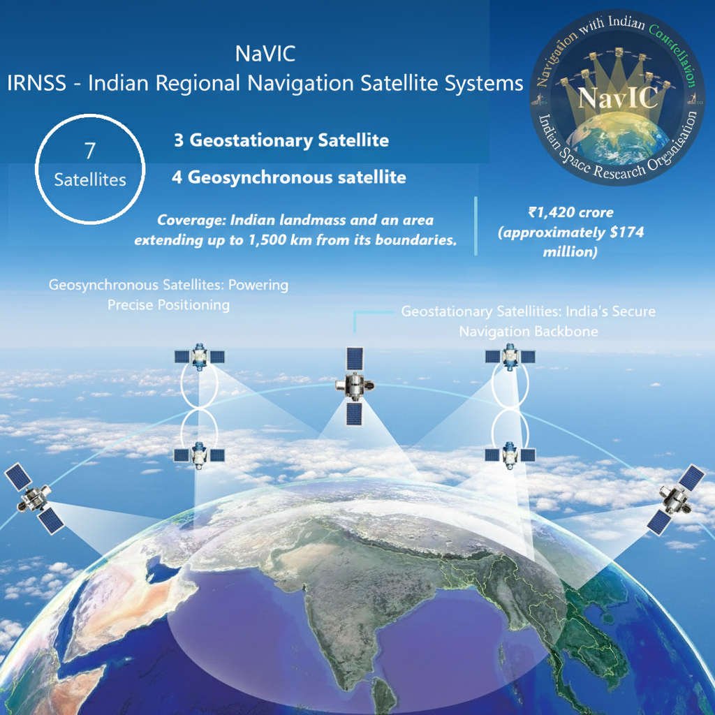
NaVIC: India’s Indigenous Navigation System
NavIC (Navigation with Indian Constellation) is India’s indigenous satellite-based navigation system developed by **ISRO**. Operational since 2018, it provides precise positioning, timing, and navigation services.
NaVIC's primary coverage area includes the entire Indian mainland and extends up to **1,500 km beyond its borders**, ensuring strategic and regional service reliability.
Why India Needed NaVIC
India’s dependence on foreign systems like GPS highlighted **vulnerabilities**, especially during crises. NavIC was developed to ensure **strategic autonomy**, uninterrupted navigation, and enhanced national security.
Satellite Constellation and Architecture
NavIC consists of a **seven-satellite constellation** placed in **geostationary (GEO) and geosynchronous (GSO)** orbits. This structure allows reliable coverage and strong signals over the Indian region.
Coverage and Service Region
Unlike global systems, NavIC is a **regional navigation system**. Its coverage spans the entire Indian mainland and extends roughly **1,500 km** beyond national boundaries, meeting India’s domestic needs.
Types of Services Offered
NaVIC delivers two key services: the Standard Positioning Service (SPS), freely accessible to all civilian users, and the Restricted Service (RS), an encrypted, high-precision signal exclusively designed for defence, security agencies, and other authorised strategic operations.
Accuracy and Performance
NavIC delivers high-precision positioning, typically achieving accuracy better than 20 metres across India. Its combination of GEO and GSO satellites ensures stronger regional coverage, making it more reliable and accurate than several global navigation systems within the Indian region.
Applications in Public Safety
NavIC supports **disaster management** through accurate location-based warnings. It transmits cyclone and tsunami alerts to fishermen and coastal communities, enabling timely evacuation.
Applications in Transport and Mobility
The system is used in **public vehicle tracking, highway toll management**, and emergency response systems. Mandatory NavIC-based tracking in commercial vehicles enhances road safety.
Support to Fisheries and Coastal Economy
NavIC-enabled devices help fishermen **navigate safely**, receive weather updates, and access real-time alerts. These features reduce risks at sea and boost productivity.
Agricultural and Rural Applications
Location-specific information supports **precision agriculture, soil mapping**, and water-use planning. Rural administrations use NavIC-based mapping for land records and developmental planning.
Role in National Security
The **encrypted Restricted Service** strengthens India’s defence preparedness. It supports military platforms, surveillance systems, and secure operations where foreign navigation systems may be denied.
Technological Development in India
NavIC reflects India’s rising capabilities in space technology. ISRO continues to upgrade the system by improving satellite life, enhancing ground infrastructure, and expanding **compatibility with smartphones**.
Future Expansion Plans
India aims to transform NavIC from a regional system to a **broader constellation with global reach**. Plans include new satellites, improved atomic clocks, and **interoperability** with global systems for increased consumer use.
Scientific & Exploration Satellites
Scientific and exploration satellites are space-based instruments designed to study **celestial bodies, physical phenomena, and deep-space environments**. They help scientists gather accurate data on cosmic events, planetary systems, and Earth’s near-space environment, improving our understanding of the universe.
These satellites mainly support advanced research by observing **radiation, particles, magnetic fields, and distant cosmic objects**. Their findings strengthen scientific theories, improve space-weather predictions, and support technological innovation in astronomy, astrophysics, and planetary science.
Scientific satellites usually carry **specialized sensors** like telescopes, spectrometers, particle detectors, and imaging payloads. They operate in specific orbits—often high-altitude or Sun-synchronous—to reduce interference, enhance visibility, and capture long-term, high-quality observational data.
Exploration satellites focus on studying **planets, moons, asteroids, and comets**. They provide images, chemical data, and environmental measurements from these celestial bodies. This helps understand their origin, evolution, and potential for supporting future human missions.
Earth-Oriented Missions
Earth-oriented scientific satellites study **climate, atmosphere, magnetosphere, and radiation belts**. Their data is crucial for understanding Earth's complex systems and how they interact with space.
Deep-Space Missions
Deep-space missions, on the other hand, explore **non-Earth environments** such as Mars, the Sun, the Moon, or interplanetary space, offering insights into broader cosmic processes and universal origins.
Remote-sensing satellites collect Earth-surface data for applications like agriculture and disaster management. Scientific satellites, in contrast, aim to understand **physical principles and cosmic behaviour**. Their focus is research rather than direct national or commercial applications.
Common payloads include **X-ray and gamma-ray telescopes, ultraviolet imagers, spectrometers** for chemical analysis, magnetometers, and plasma detectors. Each instrument helps examine a specific type of energy or particle to uncover hidden details of cosmic events.
ISRO’s scientific missions include **Astrosat** for multi-wavelength space studies, **Chandrayaan** missions for lunar exploration, and **Mangalyaan** (Mars Orbiter Mission) for studying the Martian atmosphere. These showcase India’s growing capability in planetary science.
NASA’s **Hubble Space Telescope**, ESA’s **Gaia mission**, and JAXA’s **Hayabusa missions** are global leaders in space science. They have delivered extraordinary insights into stellar evolution, dark matter mapping, and asteroid composition.
Solar exploration satellites like NASA’s **Parker Solar Probe** and ISRO’s **Aditya-L1** study the Sun’s outer layers, solar winds, and magnetic storms. Their data improves space-weather forecasting, protecting satellites, power grids, and communication systems on Earth.
These missions send **orbiters, landers, and rovers** to explore geological structures, mineral deposits, and surface conditions. The findings help reconstruct planetary history, assess habitability, and identify resources that may support future space exploration.
Such missions face challenges like **extreme temperatures, cosmic radiation, high mission costs**, long travel durations, and precision-based navigation. Ensuring reliable communication and instrument protection in deep space also makes mission design complex.
Future satellites will use advanced **AI-based instruments, miniaturized payloads, and electric propulsion**. This shift focuses on efficiency, autonomy, and capability enhancement for ambitious missions.
Upcoming missions will explore **asteroids for resource mapping, study exoplanets**, and deepen our understanding of cosmic origins and **dark-energy** phenomena, pushing the boundaries of scientific knowledge.
Space Technology: Commercialization of Indian Space Program
The commercialization of the Indian space program is driven by **policy reforms** that allow private companies to participate in all aspects of the space sector, supported by institutions like **NSIL** and **IN-SPACe**.
This has led to an increase in **private startups** and collaborations, with companies involved in launching satellites, developing launch vehicles, and providing space-based services.
Key milestones include the first **private-led Earth Observation (EO) network** and the initial manufacturing of launch vehicles like the **PSLV by private industry**.
This strategic shift aims to make India a **globally competitive player** in the space economy, foster innovation, and commercially exploit space products and services.
NewSpace India Limited (NSIL)
The government-owned **commercial arm of ISRO**, responsible for promoting and commercially exploiting space products and services, including technology transfer and the production of launch vehicles.
IN-SPACe (Indian National Space Promotion and Authorisation Centre)
Acts as a **single-window nodal agency** to enable private participation and streamline regulatory processes for Non-Governmental Private Entities (NGPEs).
Satellite Development
Private companies are involved in the **end-to-end design, development, and operation** of satellites, shifting from a purely government-led effort.
Launch Services
Startups are developing and commercializing **small-lift launch vehicles** (e.g., Vikram, Agnibaan), and private industry is now building launch vehicles like the **PSLV**.
Space-based Services
The private sector provides services such as **data analytics, communications, remote sensing, and navigation**, monetizing space assets.
Public-Private Partnerships (PPPs)
A major initiative is a PPP for a **12-satellite Earth Observation (EO) constellation** led by the private company **Pixxel**.
Technology Transfer
ISRO is actively transferring critical technologies to private companies. For example, the technology for the **Small Satellite Launch Vehicle (SSLV)** has been transferred to **HAL**.
Funding and Support
The **Technology Development Board (TDB)** supports companies like Agnikul Cosmos, while the **Technology Adoption Fund (TAF) scheme** provides funding for startups and MSMEs to promote innovation and commercialization.
Economic Growth
Commercialization is projected to **significantly boost India's participation** in the global space economy, creating new revenue streams.
Innovation and Job Creation
The increased role of the private sector is expected to drive **innovation, investment, and significant job creation** across the value chain.
Strategic Shift for ISRO
The shift allows private industry to take on production of proven vehicles, enabling ISRO to focus on **advanced R&D, new launch vehicles, space stations, and deep space missions**.
**Skyroot Aerospace** and **Agnikul Cosmos** are spearheading the development of **small-lift launch vehicles**, **Vikram** and **Agnibaan**, respectively, to capture the growing market for launching small satellites.
Vehicle: Vikram Rocket Series
Successfully launched the **Vikram-S sub-orbital demonstrator** in 2022. It is developing the orbital-class **Vikram-1** for commercial missions.
Key Achievement & Outlook
Inaugurated "Infinity" campus, India's **first private commercial rocket facility**. Aims for commercial missions in the 2024-2025 timeframe.
Vehicle: Agnibaan Launch Vehicle
Developed the **Agnibaan SOrTeD** sub-orbital demonstrator. It utilizes **3D printing** for its rocket engines and components, offering unique customization.
Key Achievement & Capability
Established **India's first private launchpad and mission control center** at Sriharikota. Agnibaan is highly customizable, capable of carrying up to 300 kg to a 700 km orbit.
Top Agencies Shaping India’s Space Future
1. Indian Space Research Organisation (ISRO)
ISRO is India’s **premier space agency** responsible for designing **satellites**, **launch vehicles**, and major missions. It focuses on cost-effective space technology, enabling applications in communication, navigation, remote sensing and national development. Missions like Chandrayaan, Mangalyaan, and Gaganyaan established global credibility.
2. Department of Space (DoS)
The Department of Space **oversees India’s overall space policy**, program planning, and budget allocation. It coordinates between ISRO, national ministries, scientific bodies, and industry partners. DoS ensures that India’s space missions align with **strategic, developmental, and commercial needs** across sectors.
3. NewSpace India Limited (NSIL)
NSIL is ISRO’s **commercial arm** responsible for converting space technology into market-ready products. It manages **satellite launches for foreign customers**, leases transponders, and promotes commercial satellite-based services. Example: NSIL took over the operational deployment of satellites like **GSAT-24** for direct-to-home broadcasting.
4. IN-SPACe (Indian National Space Promotion and Authorization Centre)
IN-SPACe acts as a **regulator and promoter for private space companies**. It grants **authorization** for satellite launches, manufacturing, and data access. Its role is to create a **level playing field** so startups can use ISRO facilities and build their own space products.
5. Defence Space Agency (DSA)
The Defence Space Agency manages India’s **military space capabilities**. It coordinates **satellite communication**, **surveillance**, and space-based strategic support for the armed forces. DSA helps integrate space technology with national security, including real-time intelligence and navigation systems.
6. Defence Research and Development Organisation (DRDO)
DRDO contributes to space by developing advanced **sensors**, **missile technologies**, tracking radars, and reusable systems. Many technologies used in India’s launch vehicles and missile defence programs have roots in **DRDO’s research**. Example: Long-range radar systems for monitoring space objects.
7. Indian National Satellite System (INSAT) Program
INSAT is a **multi-purpose satellite series** supporting **communication**, **weather forecasting**, disaster warnings, and television broadcasting. It enables nationwide connectivity, especially in remote areas. The program remains central to tele-education, tele-medicine, and rural communication networks.
8. Indian Remote Sensing (IRS) Program
IRS satellites provide **high-resolution images** essential for agriculture, water management, urban planning, and **disaster response**. For example, crop monitoring and flood mapping rely heavily on IRS data. This program ensures **India’s self-reliance** in Earth observation.
9. Private Space Startups
Startups like **Skyroot Aerospace**, **Agnikul Cosmos**, Pixxel, Dhruva Space, and Bellatrix Aerospace are driving **innovation** in small launch vehicles, satellite manufacturing, and hyperspectral imaging. They reduce costs, create jobs, and bring new technologies such as **3D-printed engines** and micro-satellite platforms.
10. International Collaborations
India partners with agencies like **NASA, ESA, CNES, and JAXA** for joint missions, data sharing, and capacity building. Such cooperation expands scientific knowledge and access to global markets. Example: **ISRO-NASA NISAR** mission for Earth systems monitoring.
11. Future-Focused Institutions
Research institutes like **IIST, PRL, and IISc** support India’s **future space workforce**. They train engineers, conduct astrophysics research, and test advanced materials. Their contribution strengthens **long-term innovation** and mission readiness.
Space-based Information Support for Decentralised Planning (SISDP) & Bhuvan
SISDP is an **ISRO initiative** that provides satellite-based information to local-level planning authorities. It helps **districts, blocks, and panchayats** use accurate **geospatial data** for natural resource management, infrastructure planning, and development monitoring.
Need for Reliable Data
India’s decentralised planning system needs reliable ground-level information. Traditional field surveys take time and vary in quality.
Addressing the Gap
SISDP fills this gap by supplying **ready-to-use spatial data** that supports quick, **evidence-based planning** at village and district levels.
The main goal of SISDP is to empower local governments with **scientific maps and datasets**. This allows officials, planners, and development workers to identify local issues such as **water scarcity, land degradation, or resource availability** with higher accuracy.
SISDP uses **remote sensing satellites, GIS tools, and field data** to produce detailed maps. These maps cover **land use, water bodies, soil types, infrastructure, and environmental changes**. The information is then provided to states through user-friendly digital platforms.
Customised Layers
A major feature is the creation of **customised district- and panchayat-level geospatial layers** tailored to specific local needs and administrative boundaries.
Geodatabase and Planning
Each district receives a **comprehensive geodatabase**, enabling local authorities to track development gaps and prepare evidence-based development plans.
Types of Maps Generated
SISDP generates maps of **land-use patterns, waste land, water resources, agriculture, forests, settlement growth**, and hazard-prone zones. These thematic maps help planners choose targeted interventions.
Application in Rural Planning
It supports schemes like **MGNREGA**, watershed development, and rural infrastructure. Planners identify suitable areas for **check dams, soil conservation trenches**, or village roads using satellite data.
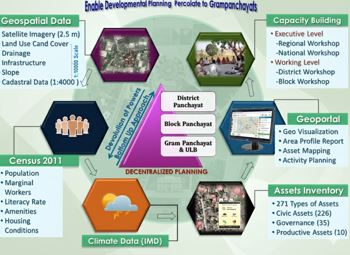
ISRO collaborates with **state remote sensing centres** to update datasets regularly. Local officers receive **training** to apply geospatial tools in planning, which improves coordination between scientific institutions and governance bodies.
ISRO's Geoportal
Bhuvan is ISRO’s **open-source geoportal** that provides satellite images, thematic maps, and 2D/3D visualisation tools.
India's Alternative
It functions as India’s alternative to platforms like Google Earth, offering more **detailed local-level information** tailored for Indian needs.
Imagery and Data
Bhuvan offers **high-resolution imagery**, crowd-sourced data, disaster maps, and sector-specific services. Users can view layers like land cover, rivers, and urban growth.
Open Access
Its **open-access nature** makes it a valuable resource for students, researchers, and administrators across the country.
Bhuvan is widely used by ministries for **monitoring national schemes**. Examples include **mapping assets under MGNREGA**, tracking road progress under PMGSY, and monitoring urban changes under AMRUT. Visual dashboards help ensure accountability and transparency.
**SISDP data is often hosted on the Bhuvan platform**, making it accessible to district authorities. **Bhuvan provides visual tools, while SISDP supplies targeted datasets**. Together, they support scientific planning, resource management, and scheme evaluation.
Future Space Development Programmes
Future space programmes aim to expand human understanding of space, enhance national capabilities, and support socio-economic development. These initiatives focus on **planetary exploration**, **advanced satellites**, **deep-space studies**, and new technologies that reduce mission costs.
Human Spaceflight Expansion
Countries are investing in safe and reliable systems for **long-duration human stays in space**. These include crewed capsules, space habitat modules, and **life-support technologies**. Such missions aim to prepare humans for future lunar and Martian exploration.
Space Stations and Habitats
Future plans include **modular space stations** capable of supporting **scientific research**, microgravity experiments, and astronaut training. These stations will promote international collaboration and offer platforms for studying materials, health, and technology in orbit.
Space agencies are developing **reusable rockets** to cut launch costs and increase mission frequency. Reusable boosters can return to Earth safely after delivering payloads. This approach aims to make **space access affordable and sustainable**.
Advanced Satellite Constellations
Future satellite networks will work in **coordinated formations** to enhance communication, navigation, and Earth observation. Constellations improve coverage, reduce delays, and offer **real-time data** for disaster management, agriculture, and climate monitoring.
Planetary Exploration Missions
Exploration missions to the **Moon, Mars, Venus, and outer planets** are planned globally. They aim to study planetary evolution, habitability, geology, and potential resources. **Sample-return missions** will bring scientific material back to Earth for detailed analysis.
Upcoming space telescopes will observe **distant galaxies, stars, and exoplanets** with greater clarity. These telescopes operate beyond Earth’s atmosphere, enabling **high-precision imaging** and helping scientists understand the origin of the universe.
Space Robotics and AI Systems
**Robotic arms, autonomous rovers**, and **AI-driven explorers** will take on complex tasks in hazardous environments. Robots can perform repairs, collect samples, and navigate difficult terrain, reducing risks for human astronauts.
Asteroid Mining Prospects
Future missions aim to study asteroids for valuable resources like **metals and water-ice**. Although still experimental, asteroid mining could support construction in space, fuel production, and **long-term deep-space missions**.
Concept projects explore harvesting solar energy directly in space and **transmitting it to Earth**. SBSP offers uninterrupted energy collection, but requires advances in **wireless power transmission** and large-scale satellite engineering.
Climate and Environment Monitoring Satellites
Future sensors will provide **sharper climate data**, enabling **early warnings** for cyclones, floods, and droughts. Improved satellites support climate modelling, carbon tracking, and global environmental protection efforts.
Defence and Space Security Initiatives
Nations are building advanced systems for **space situational awareness**, anti-collision tracking, and secure communication. These ensure safety of satellites and protect national space assets from emerging threats.
Private Sector and Start-Up Collaboration
**New-age companies** are entering launch services, satellite design, and deep-space technology. **Public-private partnerships** will accelerate innovation, reduce operational costs, and expand commercial applications of space missions.
Snapshot
Future space programmes reflect a shift toward **cost-effective exploration**, deeper scientific discovery, and **global cooperation**. These initiatives aim to strengthen space-based services while preparing humanity for **long-term presence beyond Earth**.
SLV-3
SLV-3: India’s First Experimental Satellite Launch Vehicle
SLV-3 was India’s **first experimental satellite launch vehicle** designed to place small satellites into low Earth orbit. Developed by ISRO under the leadership of **Dr. APJ Abdul Kalam**, it marked India’s entry into indigenous space launch capability.
Primary Goal
The primary goal was to **master the basic technologies of multi-stage solid-fuel rockets**. It aimed to give India the foundational understanding required to build advanced launch vehicles like PSLV and GSLV in the future.
Design & Configuration
SLV-3 was a **four-stage launch vehicle**, fully powered by **solid propellants**. Each stage fired sequentially, lifting the vehicle through atmospheric layers. Its simple structure made it ideal for learning core propulsion and guidance principles.
Key Specifications
The rocket stood around **22 meters tall** with a launch mass of about **17 tonnes**. It could carry a satellite weighing roughly **40 kilograms** into low Earth orbit. These modest numbers reflected its technology-demonstration purpose.
Technologies Mastered
SLV-3 helped India gain experience in **solid propulsion, flight guidance, staging, and mission control**. These core technologies later became the foundation for ISRO’s reliable launch systems, especially the PSLV series.
First Launch Attempts
The first SLV-3 launch in **1979 failed** due to a technical anomaly. However, ISRO used it as a learning opportunity, refining design and procedures. This failure later became a classic example of scientific resilience.
Successful Launch in 1980
On **18 July 1980**, SLV-3 successfully placed the **Rohini Satellite (RS-1)** into orbit. This made India the **sixth nation** in the world to achieve indigenous satellite launch capability, marking a major milestone in Indian space history.
Rohini Satellite Example
Rohini (RS-1) was a small **scientific satellite** used to study Earth’s atmosphere. Its successful orbital placement demonstrated that SLV-3 could reliably deliver payloads, validating ISRO’s early design efforts.
Legacy of SLV-3
SLV-3 became the **foundation stone** for India’s future launch vehicle programmes. It proved that indigenous rocketry was possible and laid the technological pathways for **ASLV, PSLV, GSLV**, and eventually **LVM-3** missions.
ASLV
ASLV – Augmented Satellite Launch Vehicle
Augmented Satellite Launch Vehicle (ASLV)
The **Augmented Satellite Launch Vehicle (ASLV)** was India’s early experimental launcher developed by ISRO during the 1980s. It aimed to create a more capable successor to the Satellite Launch Vehicle (SLV-3) and strengthen India’s small-satellite launch capability.
Purpose of Developing ASLV
ASLV was designed mainly to improve **payload capacity** and test advanced **multi-stage flight features**. It served as a stepping-stone between SLV-3 and the more reliable PSLV, helping India transition toward stable satellite launch operations.
Design and Basic Structure
ASLV was a **five-stage, solid-propellant** launch vehicle. The lower stages were derived from SLV-3 boosters, while additional **strap-on motors** provided extra thrust. This layered structure allowed ISRO to experiment with higher altitudes and improved control systems.
Payload Capacity
ASLV could place around **150 kg class satellites** into Low Earth Orbit (LEO). Though modest, this capacity was important for testing sensors, communication modules, and small experimental satellites, laying the foundation for future missions.
Key Technological Features
ASLV introduced several new technologies such as **closed-loop guidance, strap-on boosters**, and improved staging. These systems helped ISRO practice precision control—essential for later vehicles like PSLV, which uses more advanced versions of these technologies.
ASLV Flight Tests
Between 1987 and 1994, ISRO conducted **four ASLV launches**. The first two flights failed due to stability issues. The third achieved partial success, and the fourth finally succeeded, proving key concepts required for future launch systems.
Example: Why Failures Mattered
ASLV’s failures gave crucial insights into **aerodynamic instability**. For example, a slight shift in wind direction at lift-off affected vehicle balance. Understanding such issues helped ISRO design PSLV with better control and structural margins.
Significance in India’s Space Journey
Though not highly successful, ASLV was vital for **capacity building**. It trained teams in advanced staging, navigation, and mission management. These learnings directly contributed to the creation of **PSLV**, India’s most dependable workhorse launcher.
Legacy
ASLV is remembered as India’s experimental bridge between early and modern launch vehicles. Its lessons strengthened India’s confidence, enabling more complex missions, including remote-sensing launches, moon missions, and interplanetary exploration.
PSLV
Polar Satellite Launch Vehicle (PSLV) — UPSC CSE General Science Notes
The **Polar Satellite Launch Vehicle (PSLV)** is India’s most reliable medium-lift launch vehicle, developed by **ISRO**. It is known for placing satellites into polar, Sun-synchronous, and various Earth orbits with **high precision**, making it a backbone of India’s space program.
India needed an **independent and cost-effective system** to launch **remote sensing satellites** into polar orbits. PSLV filled this gap by offering dependable performance, flexible mission capability, and international launch services.
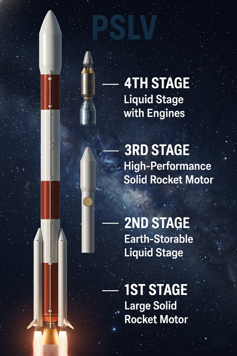
Basic Structure of PSLV
PSLV is a **four-stage rocket** that alternates between solid and liquid propulsion. The solid stages give **high initial thrust**, while the liquid stages provide **control and accuracy**. This combination ensures stability and precise orbit insertion.
Stage 1: Solid Booster
Solid booster providing **strong liftoff thrust** and initial momentum for the heavy vehicle.
Stage 2: Liquid Engine
Liquid engine offering **controllability** and throttle-down capabilities during atmospheric flight.
Stage 3 & 4: Upper Stages
Stage 3: **Solid motor** giving sustained mid-flight push. Stage 4: **Liquid stage** enabling fine orbital adjustments.
A major strength of PSLV is its ability to inject **multiple satellites into different orbits** in a single mission. This is useful for Earth observation constellations and makes PSLV attractive for foreign customers.
PSLV-G (Generic)
PSLV-G is the standard four-stage PSLV variant with six strap-on boosters, capable of launching about 1,678 kg to SSO.
PSLV-XL (eXtended)
PSLV-XL uses six extended boosters for higher thrust, enabling heavier payloads up to ~1,750 kg in 600 km SSO.
PSLV-CA (Core Alone)
PSLV-CA is a lighter, booster-free PSLV variant optimized for launching smaller payloads, like 1,000 kg to 550 km SSO.
PSLV-QL / DL / 3S
PSLV variants differ by the number of strap-on boosters, which directly affects payload capacity. More boosters mean higher lift, enabling 1019–1750 kg to SSO.
Depending on the variant, PSLV can carry **1,000–1,750 kg** to Sun-synchronous orbits and smaller payloads to Geostationary Transfer Orbit (GTO). Its optimal performance is seen in **polar and low Earth orbit missions**.
Role in Space Achievements
PSLV launched landmark missions such as **Chandrayaan-1** (2008), **Mars Orbiter Mission – Mangalyaan** (2013), and **IRNSS/NavIC** satellites. Its reliability helped India gain global recognition in affordable space technologies.
First Successful Mission
PSLV achieved its first fully successful flight in **1996 (PSLV-D3)**. Since then, it has delivered over **95% mission success rate**, making it one of the world’s most trusted launch vehicles.
Because of its **low cost and proven reliability**, PSLV is widely used to launch small satellites from countries across Asia, Europe, and the Americas. This enhances India’s reputation in the **global space market**.
PSLV reflects India’s progress in **space self-reliance**, technological innovation, and **global space diplomacy**. UPSC expects conceptual clarity—focus on stages, variants, achievements, and applications.
GSLV
GSLV Family – An Overview
The **Geosynchronous Satellite Launch Vehicle (GSLV)** series is India’s medium-to-heavy lift launch vehicle class.
Developed by **ISRO**, it fills the gap between PSLV’s lower capacity and LVM3’s heavy capability.
It is specifically designed for launching satellites into **Geostationary Transfer Orbit (GTO)**, critical for large communication satellites.
Basic Structure (Three Stages)
GSLV Mk II uses a **three-stage configuration**: a solid first stage, four liquid strap-ons, a liquid second stage, and an **indigenously developed Cryogenic Upper Stage (CUS)**, achieving self-reliance in complex cryogenic propulsion.
Key Modifications (CE-7.5 Engine)
Early GSLV versions used a Russian cryogenic engine. Mk II replaced this with India’s own **CE-7.5 cryogenic engine**, featuring better thrust and enhanced guidance for more reliable GTO missions.
Payload Capacity (Medium-Lift)
Mk II can lift **2–2.5 tonnes to GTO** (Geostationary Transfer Orbit) and around **5 tonnes to LEO** (Low Earth Orbit), making it ideal for mid-size communication and weather satellites.
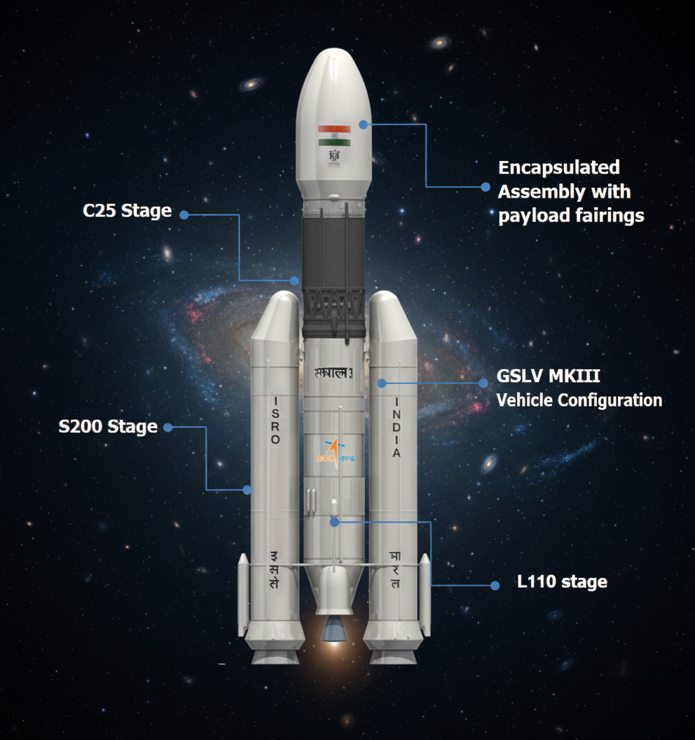
India’s Heavy-Lift Breakthrough
GSLV Mk III (renamed **LVM3**) is India’s most powerful operational launcher, with a two-solid-booster first stage, a liquid core stage, and a high-thrust cryogenic upper stage.
Advanced Design Features
It uses massive **S200 solid boosters** for initial thrust and the **C25 cryogenic stage** (powered by the CE-20 engine) for long-duration burns essential for high-energy orbits.
Payload Capacity (Heavy-Lift)
LVM3 can carry **4–4.5 tonnes to GTO** and up to **10 tonnes to LEO**. This enabled missions like Chandrayaan-3 and is crucial for India's human-spaceflight (Gaganyaan) program.
Why LVM3 Replaced “GSLV Mk III” Name
ISRO adopted the term **LVM3 (Launch Vehicle Mark-3)** to reflect its broader mission profile beyond traditional GTO launches, including commercial broadband satellites and human-rated crew module tests.
Comparison – Mk II vs. Mk III/LVM3
**Mk II** serves medium payloads for GTO, while **Mk III/LVM3** handles much heavier, high-energy missions. Mk III uses more powerful S200 boosters and the higher-capacity CE-20 cryogenic engine, making it India’s premier workhorse for demanding missions.
SSLV
Small Satellite Launch Vehicle (SSLV)
Introduction to SSLV
The Small Satellite Launch Vehicle (**SSLV**) is ISRO’s compact, three-stage launch vehicle designed specifically for placing **small satellites** into low Earth orbit. It targets the fast-growing global small-satellite market with quick, flexible, and low-cost launch options.
Purpose and Rationale
SSLV was developed to meet increasing demand for launching satellites in the **10–500 kg category**. Traditional PSLV missions are larger and costlier, making SSLV ideal for **rapid, on-demand deployments** for earth-observation, communication, and academic missions.
Key Design Drivers
SSLV emphasizes **low cost**, minimal launch infrastructure, **quick turnaround**, and the ability to accommodate multiple satellites in a single mission. This allows agencies, startups, and universities to schedule launches without long wait times.
Vehicle Configuration
SSLV is a **three-stage rocket**, with all three main stages using **solid propulsion**. A small **Velocity Trimming Module (VTM)**, using liquid propulsion, acts as the terminal stage to precisely circularize the orbit.
Stage 1 (SS1)
Large **solid booster** providing initial high thrust to lift the vehicle off the launch pad and begin the ascent phase.
Stage 2 (SS2) & Stage 3 (SS3)
**SS2** is a medium solid stage ensuring ascent stability. **SS3** is a smaller solid stage that places the vehicle close to the target orbit, preceding the final adjustment.
Velocity Trimming Module (VTM)
The VTM uses **liquid propulsion** to conduct fine orbital adjustments, ensuring high-precision velocity and positional accuracy to achieve the mission's required circular orbit.
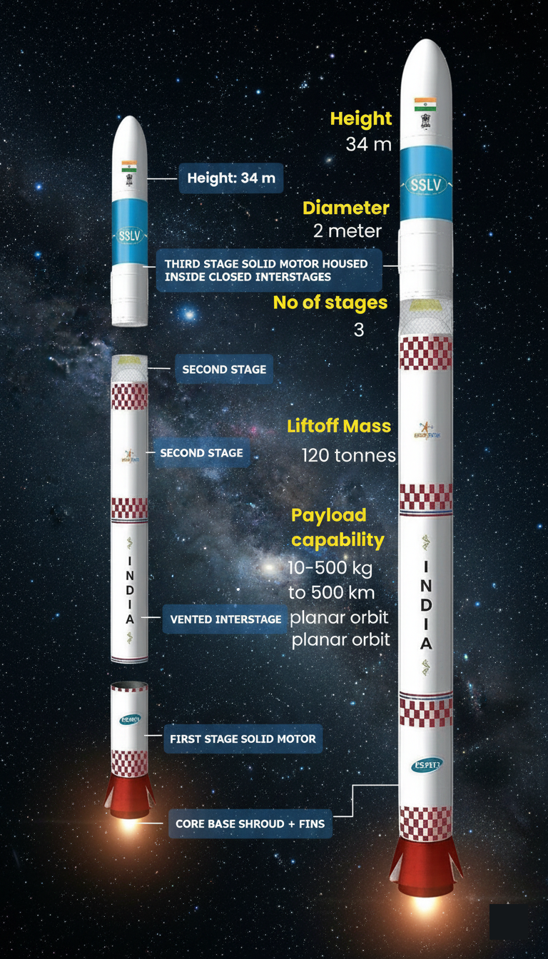
Payload Capacity
SSLV can place satellites between **10 and 500 kg** into a **500 km planar orbit**. This makes it perfectly suitable for launching micro- and mini-satellite missions, including the growing trend of **constellation deployments**.
Launch Flexibility
SSLV can launch from **Sriharikota (SHAR)** for inclined orbits. For polar launches, ISRO is constructing a new dedicated launch complex at **Kulasekarapattinam, Tamil Nadu**, which will reduce fuel requirements and improve launch efficiency.
Development Journey
ISRO developed SSLV as a **rapid-manufacturing vehicle** that can be assembled in weeks instead of months. This approach is key to helping India compete with global small-launch providers by offering significantly faster launch timelines.
Commercialization Efforts
To expand production, ISRO is transferring SSLV technology to Indian industries. **Hindustan Aeronautics Limited (HAL)** became the first company to receive this technology through an agreement involving ISRO, NSIL, IN-SPACe, and HAL.
Future Prospects
Once mass-produced, SSLV is expected to offer crucial **on-demand launches**, support the deployment of large commercial satellite constellations, and contribute significantly to **India’s expanding space economy** and global launch market share.
RSLV
Launch Vehicles in India: RSLV & Pushpak (RLV)
India uses various launch vehicles to place satellites into orbit. These vehicles differ in structure, stages, and technology. Two important concepts in modern launch systems are **RSLV (Reusable Satellite Launch Vehicle)** and **Pushpak**, ISRO’s winged Reusable Launch Vehicle.
Concept
A **Reusable Satellite Launch Vehicle (RSLV)** is a rocket system designed to be used multiple times, reducing the cost per launch. Instead of discarding all parts, major components—like boosters or the first stage—are recovered and refurbished.
Key Features & Benefits
RSLVs focus on **recovery, re-entry control, and autonomous landing**. Their major benefits include lower launch cost, higher mission frequency, and reduced material wastage. This makes space access more affordable in the long term.
**Pushpak** is ISRO’s experimental, airplane-like, winged Reusable Launch Vehicle. It aims to demonstrate whether India can build a fully reusable first-stage system. The name draws inspiration from the ancient **“Pushpak Viman”** in the Ramayana.
Structure
Pushpak consists of a **lifting-body structure**, thermal protection tiles, rudder-controlled wings, and landing gear.
Mission Design
It's meant to be the **reusable first stage** of a future two-stage system: **Stage 1 (Reusable)**: Winged vehicle returns to Earth like an aircraft. **Stage 2 (Expendable)**: Conventional rocket stage inserts satellites into orbit.
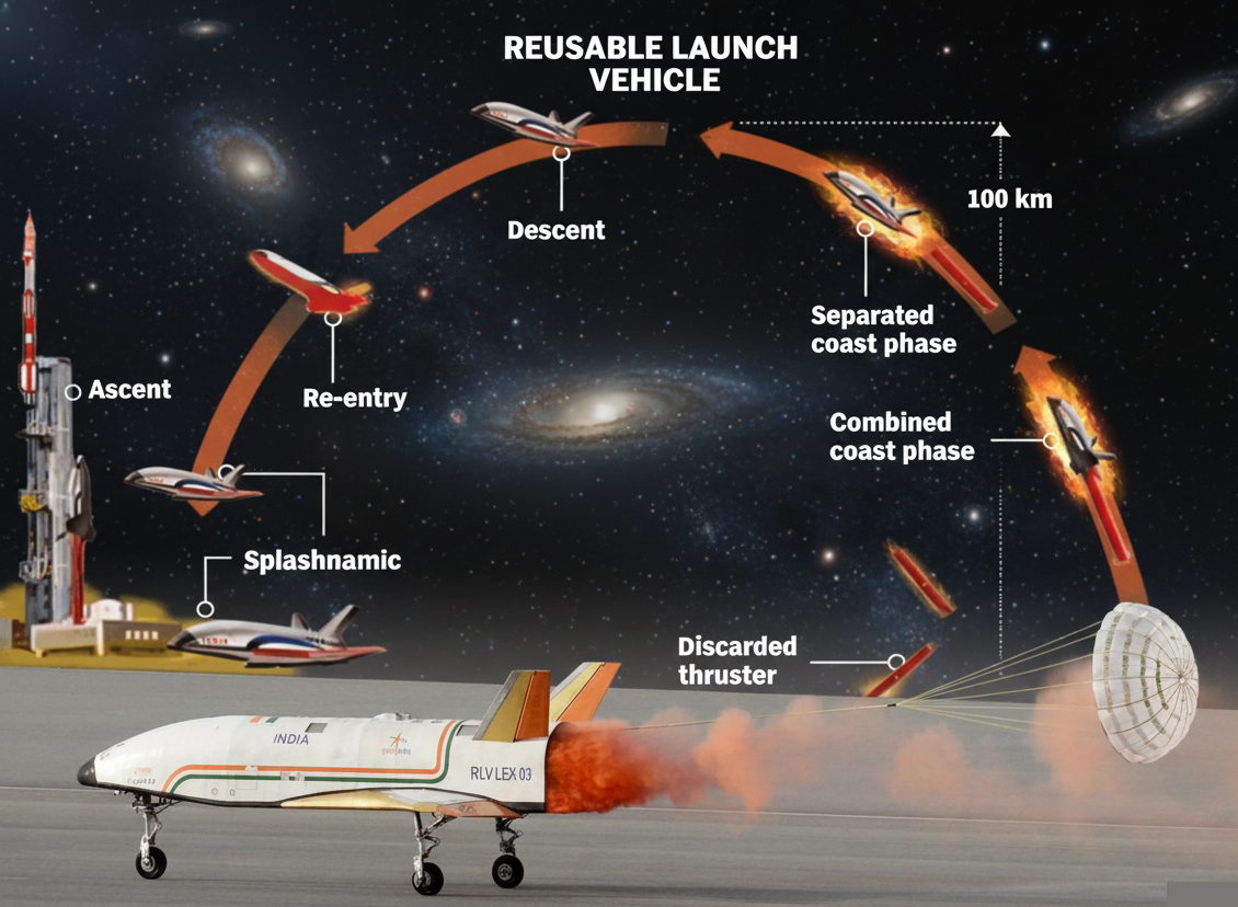
Modifications
Modifications across test missions focused on better aerodynamics, faster response surfaces, and an improved **autonomous landing algorithm**.
ISRO aims for RLV-based systems to eventually carry **4–6 ton class LEO payloads**, similar to existing heavy-lift rockets. Pushpak demonstrations help validate technologies for such future capacities.
LEX Missions
LEX missions test **autonomous landing after re-entry**. **LEX-03**, the final and most crucial test, took place on **23 June 2024** at Chitradurga. Pushpak was dropped from an IAF Chinook at 4.5 km altitude.
Landing Achievements
Pushpak autonomously performed **course correction, alignment, and a precise runway touchdown**—a key milestone for high-speed, unpowered landings. Technologies included multi-sensor fusion, radar altimeters, and **NavIC-based navigation**.
Pushpak validates India’s progress toward **low-cost, high-frequency space launches**. ISRO's long-term goal is a fully operational Reusable Launch System, cutting launch costs by up to **70%**, and strengthening India’s competitive edge in the global space market.
Low Earth Orbit Satellites
Low Earth Orbit (LEO) Satellites
LEO satellites are spacecraft operating at altitudes between **160 km and 2,000 km** above Earth. They move rapidly, completing one orbit in about **90–120 minutes**.
Their **closeness to Earth** ensures high-resolution imaging and **low communication delay** (low latency), which are critical for real-time applications.
**Atmospheric Drag:** LEO satellites experience **stronger atmospheric drag** due to residual air, which shortens lifespan and necessitates more fuel for periodic orbital corrections (**station keeping**).
**Revisit Time:** Shorter orbital periods enable **frequent revisits** over the same region, making them ideal for constant monitoring and Earth observation.
**Signal Latency:** Low altitude results in **low signal latency** (delay), which is crucial for applications like fast internet and video conferencing.
Real-Time & Imagery
LEO is preferred where **real-time communication** or **detailed imagery** is essential. Lower distance reduces signal loss, enabling clear data transmission.
Key Applications
This makes LEO especially suitable for **disaster mapping**, **broadband services**, **scientific missions**, and **military surveillance**.
Earth Observation Satellites
Capture **high-resolution images** of land, oceans, and forests. They support agriculture, climate research, and resource mapping. **Examples:** ISRO’s Cartosat, RISAT, and Resourcesat series.
Communication Constellation Satellites
Deploy hundreds of LEO satellites to provide **global internet coverage** with low latency. Large constellations are necessary as each satellite covers a small area. **Examples:** Starlink, OneWeb, and Amazon’s Kuiper Project.
Scientific and Climate Satellites
Used for scientific missions studying atmosphere, radiation, oceans, and **climate change indicators** like glacier retreat and sea-level rise. **Examples:** NASA’s Aqua, Terra, and ISRO’s climate missions.
SSO Concept
SSO is a special type of LEO satellite that passes over the **same location at the same local solar time daily**. This ensures **uniform sunlight conditions** for consistent imagery.
How SSO Works
The orbit is slightly tilted to match Earth’s rotation and orbital precession, keeping **sunlight angles constant**. This is ideal for environmental monitoring and cartography.
Remote Sensing
Monitoring **crop health**, water bodies, deforestation, and coastline changes for sustainable development.
Disaster Management
Providing rapid imagery for **flood mapping**, wildfire detection, and damage assessment after natural calamities.
Communication and Navigation
Enabling **low-latency internet**, secure data transmission, and supporting ground-based navigation systems.
Security and Science
Used for **border surveillance**, strategic intelligence, atmospheric data collection, and essential **climate studies**.
Performance Benefits
Key advantages include **low communication delay** (latency), higher data transfer rates, and **clearer, high-resolution images**.
Logistical Benefits
They require **reduced launch energy** and enable smaller satellites to be launched in clusters, supporting **rapid deployment** and easy upgrades.
Space Debris & Congestion
LEO is facing increasing **congestion** due to mega-constellations, significantly raising the risk of **collisions and space debris** (Kessler Syndrome).
Short Lifespan
**Atmospheric drag** shortens a satellite's natural lifespan, necessitating **periodic re-boosting** with fuel to maintain orbit or controlled de-orbiting.
ISRO's Role
India, through ISRO, has strong LEO capabilities with Earth observation missions. Satellites like **Cartosat-3**, **RISAT-2B**, and **Oceansat-3** strengthen national imaging and climate monitoring.
Private Sector Contribution
Private players such as **AstroSat Labs** and the **Bharti-OneWeb collaboration** are driving India's LEO communication footprint, focusing on commercial applications.
Medium Earth Orbit Satellites
Medium Earth Orbit (MEO) Satellites
Medium Earth Orbit (MEO) satellites operate between 2,000 km and 35,786 km above Earth. They serve as a “middle layer” between Low Earth Orbit (LEO) and Geostationary Orbit (GEO), balancing coverage, speed and communication reliability.
Key Orbital Characteristics
MEO satellites follow stable, wide orbits with **moderate latency** and **long visibility periods** over specific regions. Their orbital period typically ranges from 2 to 12 hours, allowing repeated coverage without the constant shifts seen in LEO systems.
Why MEO Is Important
MEO orbits offer a **sweet spot** for communication and navigation systems. They reduce the high signal delay of GEO satellites while maintaining a larger coverage footprint than LEO, making them ideal for **global services like navigation**.
4. Navigation Satellites
Most global navigation systems use MEO. These satellites ensure **precise positioning, timing and navigation**. Examples include GPS (USA), Galileo (EU), BeiDou (China) and GLONASS (Russia).
5. Communication Satellites
Some operators deploy MEO satellites for **broadband communication**. They offer lower latency and broader coverage than GEO systems. O3b mPOWER, for example, uses MEO to provide high-speed global internet connectivity.
6. Scientific and Weather Monitoring Satellites
A few scientific missions use MEO to study Earth’s **radiation belts, atmospheric patterns and space weather**. The orbit’s stability makes it ideal for long-term environmental research.
7. Global Navigation and Timing
MEO satellites power essential navigation applications—**aviation routing, maritime operations, road mapping**, surveying and disaster response. Their precise timing signals also support banking, telecom networks and power grid synchronization.
8. Strategic and Defence Uses
Countries depend on MEO-based navigation for **guided weapons, secure communication, military logistics** and battlefield coordination. Reliable MEO navigation enhances accuracy during strategic missions.
9. Global Broadband Services
MEO constellations provide **high-speed internet** to remote areas, islands and ships. They deliver lower latency than GEO satellites, supporting real-time applications such as video conferencing and cloud services.
10. Space Research and Radiation Studies
MEO provides a vantage point for observing the **Van Allen radiation belts**, enabling scientists to monitor space radiation, solar storms and magnetospheric behaviour.
11. Indian Navigation Efforts (NaVIC)
India’s **NaVIC** system primarily uses GEO and inclined-GEO satellites, but ISRO plans future upgrades that may include **MEO satellites** to expand accuracy and global reach. This aligns NaVIC with other international navigation standards.
12. Defence and Communication Plans
India is exploring MEO-based technologies for **secure military navigation, advanced communication networks** and future space-based internet. These developments aim to reduce dependence on foreign systems for strategic requirements.
13. Private Sector Initiatives
Indian private companies are collaborating on next-generation satellite communication systems. **MEO-based broadband services**, in partnership with global operators, may soon enhance connectivity in rural India.
14. Future Outlook
India’s long-term space vision includes broader participation in navigation, telecom and space science through MEO platforms. Upgrading NaVIC and adopting MEO for communication can **significantly boost national capability**.
Geostationary Satellites
Geostationary & Geosynchronous Satellites
Earth-orbiting satellites follow different paths depending on their purpose. Among these, **geosynchronous** and **geostationary** orbits are crucial for communication, weather monitoring, and strategic applications due to their stable, predictable positions relative to Earth.
A **geosynchronous satellite** revolves around Earth with the same time period as Earth’s rotation—**24 hours**. It appears to trace a **repeating path** in the sky daily but does not stay fixed over one point.
Orbit Type
These satellites typically follow a **tilted** or **elliptical orbit**, causing them to move north–south or form a **figure-eight pattern** when seen from Earth.
Altitude
Their altitude remains around **35,786 km** above Earth’s equator, matching the orbital period required for a 24-hour revolution.
A **geostationary satellite** is a **special type of geosynchronous satellite** placed directly above the **equator**. It matches Earth’s rotation and remains **fixed over a single geographic point**, making it ideal for constant coverage.
Zero Inclination
These satellites require a **zero-inclination, circular orbit**. This ensures they do not drift north or south, maintaining their position relative to the equator.
Continuous Link
Their fixed position creates a **continuous line-of-sight link** with large portions of the Earth, which is vital for uninterrupted communication and observation.
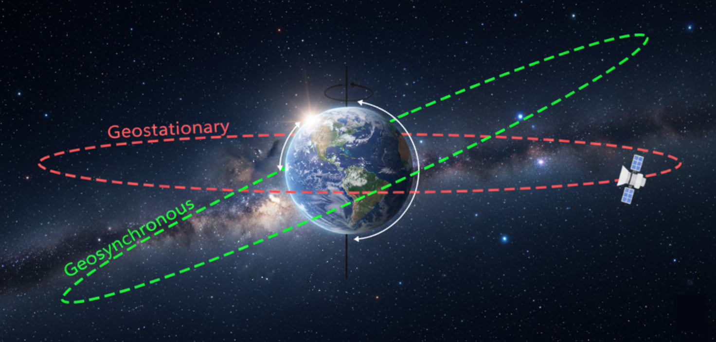
A **geosynchronous satellite** synchronizes with Earth’s rotation but may **oscillate** in the sky. A **geostationary satellite** stays **motionless** relative to an observer on Earth. Thus, **all geostationary satellites are geosynchronous, but not all geosynchronous satellites are geostationary.**
Communication Satellites
Used for **TV, internet, and telephony**, providing vast coverage areas for broadcasting and data links.
Weather Satellites
Provide continuous cloud and cyclone monitoring, essential for **meteorological observations and disaster warnings**.
Navigation Satellites
Used to support **timing and position accuracy** for global navigation systems (though the main constellation is typically Medium Earth Orbit).
Military Satellites
Provide secure communication links and constant **surveillance capabilities** over critical regions.
Maintaining a constant coverage area helps create **stable communication links**. This makes them essential for **broadcasting, disaster early-warning services**, high-altitude meteorological observations and strategic information flows.
Being fixed over a single longitude enables **uninterrupted observation**. Meteorologists, broadcasters, and defence agencies benefit because **antennas need not track movement**. Simple **fixed-dish setups** are sufficient for reliable data reception.
Broadcasting and Communication
**Direct-to-Home (DTH) TV**, satellite phones, and global broadcasting all rely on the fixed coverage of GEO satellites.
Weather and Emergency
GEO systems provide constant **weather alerts** and support **emergency communication** during disasters in remote regions.
India has built a strong presence in geostationary and geosynchronous satellites through **ISRO**. Key systems include **INSAT** for communication, **GSAT** for high-capacity data links, and **GSLV** launch vehicles to place them in orbit.
INSAT Series
Supports **telecommunication, meteorology, search-and-rescue**, and broadcasting, serving as a multi-purpose workhorse.
GSAT Series
Enhances **broadband, navigation augmentation**, and strategic communication. These satellites form the backbone of India’s space-based services.
India’s **GSLV and GSLV-Mk III** vehicles enable the launch of heavier GEO satellites. This reduces foreign dependence and strengthens national capability to deploy advanced communication and security-oriented payloads.
Technological Upgrades
ISRO is working on **high-throughput satellites**, **electric-propulsion spacecraft**, and more secure communication systems to enhance efficiency.
Infrastructure Expansion
With rising demand for digital connectivity, India is steadily **expanding its GEO-based infrastructure** to support national development goals.
Indian Remote Sensing Satellites
Indian Remote Sensing (IRS) Satellites
India's IRS satellite programme is one of the world’s largest networks dedicated to **Earth observation**. Launched by ISRO, these satellites provide continuous, reliable imagery used for development planning, environmental monitoring, and disaster management across the country.
The IRS journey began with **IRS-1A in 1988**, marking India’s entry into space-based Earth observation. Over time, satellite capabilities improved—from basic land imaging to **high-resolution, multispectral, and hyperspectral observations** for diverse national needs.
Remote sensing satellites capture information about the Earth’s surface **without contact**. By analysing reflected sunlight or emitted radiation, they help **map resources, detect environmental changes**, and support evidence-based governance and planning.
Major satellites include **Resourcesat** (agriculture, land use), **Cartosat** (high-resolution mapping), **Oceansat** (ocean data), **RISAT** (all-weather radar imaging), and **Hyperspectral Imaging Satellite** (mineral mapping). Each serves specialised developmental goals.
IRS satellites carry sensors like **LISS, AWiFS, PAN, and SAR**, which capture data at varying resolutions. These sensors differentiate features such as crops, water bodies, or urban areas, improving India’s capacity for detailed mapping and monitoring.
Crop Monitoring and Yield
Remote sensing helps estimate **crop acreage**, monitor health, and predict yields. Programmes like **FASAL** use satellite data to guide agricultural planning, reduce uncertainties in production forecasts, and support targeted interventions for farmers.
Land Use Mapping
Detailed imagery supports analysis of **land use and land cover (LULC)** changes, identifying areas for crop expansion, soil degradation, and implementing soil conservation and land management practices.
Resource Mapping
IRS imagery supports **watershed planning, groundwater prospect mapping**, and reservoir monitoring. This is crucial for managing scarce water resources efficiently across different regions.
Drought and Irrigation
It helps identify **drought-prone zones**, check canal irrigation efficiency, and guide schemes like **PMKSY** (Pradhan Mantri Krishi Sinchayee Yojana) with accurate water-resource assessments.
Rapid Data Delivery
During floods, cyclones, landslides, and forest fires, IRS satellites deliver **rapid, real-time data**. This is essential for effective situational awareness and early warning dissemination.
Relief Planning
The data enables timely **evacuation, damage assessment**, and relief planning. Systems like **NDM-DM** (National Disaster Management-Decision Support) rely heavily on satellite-enabled decision support.
Master Planning
**Cartosat-class satellites** provide high-resolution images useful for preparing **master plans**, tracking urban growth, and planning transport networks in a systematic manner.
Smart City Support
**Smart City projects** often use satellite layers to improve **land-use management** and traffic solutions by providing accurate, up-to-date spatial information.
IRS data helps track **deforestation, biodiversity loss, wetland degradation, and coastline changes**. Programmes like **Forest Cover Mapping** and Wasteland Atlas use satellite inputs to support conservation and climate-action strategies.
Remote sensing strengthens **evidence-based policymaking**. By improving resource allocation, monitoring government schemes, and supporting rural livelihoods, IRS satellites enhance **transparency, reduce wastage**, and contribute to inclusive development.
From **food security** to water sustainability, India’s IRS programme underpins major sectors. It bridges information gaps, supports **sustainable development goals**, and reinforces India’s emerging status as a global leader in affordable space technology.
The **IRS system** is a cornerstone of India’s space-driven development model. With continuous upgrades and expanding applications, remote sensing will remain **vital for governance, planning, climate resilience**, and future socio-economic progress.
Indian National Satellite System
Indian National Satellite System (INSAT)
Indian National Satellite System (INSAT)
A key pillar of India’s space-based communication and meteorology network, **INSAT** is one of the largest domestic satellite systems in the Asia-Pacific region. Launched in 1983, it supports communication, broadcasting, weather services, and disaster management through a **multi-purpose satellite fleet**.
INSAT is a **multi-purpose geostationary satellite series** developed by ISRO. It integrates communication, meteorology, broadcasting, and search-and-rescue capabilities on one platform, making it a strategic **national asset** for development and governance.
The system began with **INSAT-1B in 1983**, which successfully demonstrated India’s ability to run a large communication satellite.
Over time, **INSAT-2, INSAT-3, and INSAT-4 series** enhanced transponder capacity, weather imaging, and disaster warning services.
INSAT satellites operate in **geostationary orbit** at **~36,000 km**, allowing constant coverage over India and surrounding regions. This stationary position enables **stable communication links** and **continuous weather observation**—critical for television broadcasting and cyclone tracking.
A major feature is the combination of **communication transponders, meteorological sensors**, and data-relay instruments in one satellite.
This multi-purpose nature reduces mission costs, improves system reliability, and ensures **wide service outreach** across sectors simultaneously.
INSAT provides telephone links, **VSAT networks**, mobile communication, **DTH television**, and radio broadcasting. For example, DTH services and national television networks rely heavily on INSAT transponders for uninterrupted **nationwide coverage**.
Meteorological and Climate Services
INSAT carries payloads like CCD imagers to monitor clouds and land temperatures. These help in **monsoon forecasting, cyclone prediction**, and short-range weather alerts, supporting farmers, fishermen, and disaster agencies.
Disaster Warning and Response
The INSAT **Disaster Warning System (DWS)** transmits cyclone alerts to coastal regions through fixed receivers. Its **search-and-rescue transponders** assist in locating distressed aircraft and marine vessels in emergencies.
Socio-Economic Applications
INSAT supports **tele-education, tele-medicine, rural broadcasting**, and e-governance. Remote villages receive educational lessons and health consultations through satellite-based communication, **bridging gaps** in physical infrastructure.
Support to Government Schemes
The system enables services like **EDUSAT networks**, digital classrooms, disaster-related communication under NDMA, and rural connectivity projects. This strengthens **public service delivery** and aids inclusive development across the country.
INSAT weather data helps forecast **rainfall, drought, and heatwaves** for agricultural planning and crop management.
Fishermen receive **sea-state information and cyclone warnings**, reducing risks and improving livelihoods in coastal communities.
Technological Upgrades
Newer satellites like **INSAT-3D and 3DR** include advanced imagers, atmospheric sounding, and improved communication bands. These enhance numerical weather prediction, aviation safety, and **digital connectivity**.
INSAT vs. GSAT Transition
While INSAT focused on **multi-purpose** roles, newer **GSAT** satellites specialize in **communication**. Together, they expand India’s satellite communication capacity and reduce **dependence on foreign transponders**.
Snapshot: INSAT is central to India’s communication, broadcasting, weather forecasting, and disaster-management ecosystem. Its socio-economic impact—from digital education to safer coastal communities—shows how space technology directly supports national development and everyday life.
Indian Navigation Satellites
Indian Navigation Satellite Systems
India has developed a set of **satellite-based navigation systems** to improve accuracy, reliability and independence in positioning services. These systems support aviation, marine safety, disaster response, ground transport and digital governance.
GAGAN System Overview
GAGAN (GPS Aided GEO Augmented Navigation) is India’s **Satellite-Based Augmentation System (SBAS)**. It enhances GPS signals using corrections from GEO satellites and ground stations, providing high accuracy for aviation and safety-of-life operations.
Aviation Significance
GAGAN allows aircraft to perform **precision landings** even in low visibility. It reduces flight delays, saves fuel, improves route efficiency and enhances safety, especially for airports lacking Instrument Landing Systems (ILS).
More reliable air navigation boosts **regional connectivity** under UDAN, increases tourism, and reduces operational costs for airlines. Better landing accuracy also promotes economic development in smaller towns.
Compact Navigation Support
GAGAN Mini is a **lightweight, portable augmentation receiver** designed mainly for drones, small aircraft and ground vehicles. It enables high-accuracy navigation where full GAGAN equipment is not feasible.
Wider Application Benefits
Its compact nature supports **affordable precision agriculture drones**, land-survey tools and logistics robots. This widens GIS access for farmers, startups and small enterprises.
GEMINI (GAGAN Enabled Mariner’s Instrument for Navigation and Information) is a handheld device that provides fishermen with **position data, weather updates and disaster alerts**. It works even when mobile networks fail.
Disaster Alert & Safety
By warning fishermen about **cyclones or high waves**, GEMINI reduces marine accidents and loss of life. Improved route guidance also saves fuel and supports sustainable fishing livelihoods.
NaVIC System Coverage
NaVIC (Navigation with Indian Constellation) is India’s autonomous satellite navigation system covering India and **1,500 km beyond**. It uses a mix of GEO and inclined orbit satellites to deliver accurate timing and positioning.
NaVIC offers two types of services: **Standard Positioning Service (SPS)** for civilians and **Restricted Service (RS)** for strategic users. It provides stable signals even in remote, hilly or dense urban areas.
Daily Life Integration
NaVIC integration in smartphones, vehicle trackers and wearables helps with **navigation, emergency response** and delivery services. Its reliability supports digital payments, telecom networks and disaster management.
Governance & Strategic Autonomy
Government departments use NaVIC for **border surveillance**, road asset monitoring, mining regulation and railway safety. Its encrypted service strengthens strategic autonomy and reduces foreign dependency.
India’s journey started with reliance on GPS but expanded to developing GAGAN for aviation and NaVIC for regional independence. Innovations like **GEMINI and GAGAN Mini** illustrate India’s push for inclusive, user-centric navigation solutions.
Upcoming Upgrades
ISRO plans to upgrade NaVIC with **L1 frequency** for wider global adoption and introduce low-cost receivers for agriculture, drones and shipping. These steps will deepen India’s navigation capabilities and economic impact.
Summary Note
India’s ecosystem of navigation systems—from augmentation (GAGAN) to regional constellation (NaVIC) and safety tools (GEMINI)—demonstrates a commitment to **self-reliance** in critical technology for both civilian and strategic sectors.
Meteorological Satellites
Meteorological Satellites
Meteorological satellites are **space-based platforms** that observe Earth’s atmosphere, oceans, and land surfaces to monitor weather and climate. They provide **continuous, large-area coverage**, helping scientists detect cloud patterns, storms, temperature changes, and moisture levels with high accuracy.
These satellites address the limitations of ground-based weather stations, especially in **remote oceans** and sparsely populated areas. By offering **real-time imagery and data**, they enable better weather prediction, disaster management, and long-term climate assessment.
Geostationary Satellites
They remain **fixed over one location** relative to Earth, making them extremely useful for **rapid, continuous monitoring** of a specific region for features like rapidly developing storms and cloud movement.
Polar-Orbiting Satellites
These satellites travel around the Earth from pole to pole, allowing them to **cover the entire planet** in multiple passes daily, providing global data essential for long-term forecasting.
Most satellites carry sensors like **visible and infrared imagers**, **microwave radiometers**, and atmospheric sounders. These instruments detect heat, cloud height, wind flow, humidity, and rainfall intensity. For example, **microwave sensors** can capture cyclone structure even through dense clouds.
Weather Forecasting
They improve short-term and long-term forecasts by tracking monsoons, cloud movement, temperature variations, and wind patterns. Early identification of low-pressure systems strengthens preparedness for **extreme weather events**.
Cyclone Tracking and Disaster Management
Satellite images allow **early detection of cyclones** forming over oceans. Continuous monitoring reveals changes in intensity, helping agencies issue **timely warnings** and guide evacuation and relief efforts effectively.
Accurate weather data supports farmers in planning sowing, irrigation, and harvesting. Monitoring droughts and rainfall variability improves **crop advisories**. Industries like aviation, shipping, and fisheries also depend on satellite forecasts to **minimize risks** and optimize operations.
Climate Studies
Long-term satellite records help track **global warming**, melting ice caps, sea-level rise, and changes in vegetation cover. This data strengthens national climate policies and helps India meet global environmental commitments.
Environmental Monitoring
Satellites monitor phenomena like aerosols, dust storms, and **forest fires**. This is crucial for air quality assessment and understanding regional pollution transport, which directly impacts public health.
India began its journey with the **INSAT series**, integrating communication and weather observation. The initial Meteosat-based services were replaced by indigenous capability, and ISRO enhanced imaging quality, coverage, and data delivery for domestic needs.
INSAT-3D, 3DR, 3DS
These are the core systems, equipped with advanced **imagers and atmospheric sounders**, forming the **backbone of IMD's** operational weather forecasting and disaster warning capabilities.
Oceansat Series and SCATSAT-1
The Oceansat series supports **ocean wind** and chlorophyll monitoring, while **SCATSAT-1** assists cyclone prediction through its dedicated scatterometer data for surface wind vector mapping.
Weather data from satellites supports national schemes such as **PMFBY (crop insurance)**, Smart Cities planning, and **disaster early-warning systems**. State governments rely on satellite-based rainfall and flood forecasts to manage reservoirs and reduce vulnerability.
ISRO is strengthening **numerical weather models** and planning next-generation satellites with **AI-enabled processing**. Integration with global networks like EUMETSAT and NOAA will improve accuracy, building a robust, **self-reliant** weather and disaster management ecosystem.
Chandrayaan-1
Chandrayaan-1 Mission
Introduction
Chandrayaan-1, launched in **2008**, was India’s **first lunar mission** under ISRO’s Chandrayaan programme. It aimed to study the **Moon’s surface, mineral composition, and environment** using high-precision instruments. The mission marked India’s entry into deep-space exploration.
Mission Objectives
The mission sought to create a **detailed lunar atlas**, identify **mineral resources**, detect **water or hydroxyl signatures**, and map the lunar topography. These objectives improved scientific understanding of the Moon’s evolution.
Launch Vehicle Used
Chandrayaan-1 was launched aboard the **PSLV-C11**, a modified version of the Polar Satellite Launch Vehicle. PSLV’s high reliability suited it for sending payloads into highly elliptical orbits.
Spacecraft Configuration
The spacecraft was a **cube-shaped module** weighing around **1380 kg**, equipped with solar panels and advanced communication antennas. A balanced design ensured long operational life and stable lunar orbiting.
Development Background
ISRO developed Chandrayaan-1 using **indigenous technologies**, though several instruments were international collaborations. The mission showcased India’s growing expertise in remote sensing and planetary science.
International Collaboration
Among the 11 onboard payloads, **five were from foreign space agencies** including **NASA, ESA, and Bulgaria**. This cooperation improved scientific capacity, data sharing, and global credibility.
Indian Instruments
Key instruments included **Terrain Mapping Camera (TMC)**, **Hyper Spectral Imager (HySI)**, and **Moon Impact Probe (MIP)**. These tools mapped surface features and analysed minerals for Indian scientific output.
International Instruments
NASA’s **Mini-SAR** searched for polar ice deposits, while **Moon Mineralogy Mapper (M3)** identified water and hydroxyl molecules. European instruments examined X-ray emissions and solar wind.
Key Role
The MIP separated from the orbiter and **impacted the lunar surface** near the south pole. It conducted short-duration measurements of the exosphere and **famously carried the Indian flag**, symbolising national presence on the Moon.
Major Discoveries
Chandrayaan-1 **confirmed the presence of water molecules and hydroxyl (OH–)** on the lunar surface, especially near the poles. High-resolution maps revealed volcanic plains, craters, and crustal composition.
Significance of Water Discovery
The detection of water signatures revitalised interest in lunar exploration by suggesting potential **resources for future habitats, fuel production**, and long-term scientific missions.
Mission Challenges
The mission ended earlier than planned due to **overheating issues** and communication loss. However, data collected during its ten months of operation exceeded several scientific expectations.
Overall Significance
Chandrayaan-1 **elevated India into the group of global lunar explorers**. Its achievements strengthened India’s scientific capabilities, inspired future missions like Chandrayaan-2 and 3, and placed **ISRO prominently** in international planetary research.
Chandrayaan-2
Chandrayaan-2 Mission
Chandrayaan-2 is India’s second lunar mission, launched in **July 2019** to explore the Moon’s south polar region. It aimed to demonstrate **soft-landing capability**, rover mobility, and detailed remote sensing studies. The mission had three components: **Orbiter, Vikram Lander, and Pragyan Rover**.
Scientific Goals
The mission sought to **map lunar terrain**, study minerals, detect **water ice**, and analyze exosphere characteristics.
Technological Goal
A major objective was achieving India’s first controlled **soft-landing on the Moon**—an advanced capability crucial for future deep-space missions.
The lunar south pole contains areas of permanent shadow, believed to store ancient **water ice**. Its untouched geology preserves early Solar System history. Studying this region can improve understanding of lunar evolution and support future human missions by using local resources.
Launch Vehicle
Chandrayaan-2 was launched aboard **GSLV Mk-III (LVM-3)**, India’s most powerful rocket.
Trajectory
Its high thrust allowed carrying the heavy composite module to a highly elliptical Earth orbit before moving toward the Moon through a series of **orbit-raising maneuvers**.
The **orbiter** remained in lunar orbit, performing remote sensing tasks. **Vikram Lander** was designed for a soft landing and to deploy the **Pragyan Rover**. The rover, powered by solar energy, planned to explore around 500 meters and relay data through Vikram.
Orbiter Instruments
The orbiter carried eight instruments, including a **Terrain Mapping Camera, Solar X-ray Monitor**, and an **Imaging Infrared Spectrometer**.
Function
These helped create high-resolution 3D lunar maps, analyze **mineral distribution**, and study the **exosphere’s composition** for long-term scientific insights.
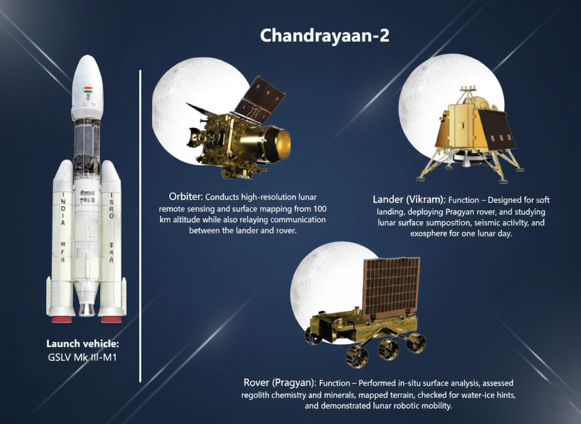
**Vikram** carried **seismometers, thermal probes**, and Langmuir probes to study moonquakes, subsurface temperature, and plasma environment. **Pragyan** housed two spectrometers to identify elements like **magnesium, aluminum, and calcium** directly from the lunar soil.
Technical Issue
During descent, unexpected deviations occurred in Vikram’s **velocity and orientation**. A software-handling limitation during the fine-braking phase caused loss of control.
Outcome
Communication broke **2.1 km above the surface**, leading to a **hard landing** instead of a controlled touchdown.
The **orbiter continues to function exceptionally**, delivering high-quality data. It mapped **water molecules** with improved precision, monitored craters, and provided detailed mineral signatures. This long-term scientific output preserved the overall mission’s high value.
Technological Leap
Chandrayaan-2 strengthened India’s autonomous **deep-space capabilities**. It improved engineering in navigation, propulsion, and hazard detection.
Future Missions
The partial failure provided critical learning, directly contributing to the **successful Chandrayaan-3 soft landing in 2023**.
Chandrayaan-3
Chandrayaan-3 Mission
Chandrayaan-3 is **India’s third lunar exploration mission** designed to achieve a **soft landing** on the Moon’s south polar region. It consists of a lander (**Vikram**) and rover (**Pragyan**), aiming to demonstrate safe landing, mobility, and basic scientific experimentation on the lunar surface.
Vikram Lander
The lander is designed for **precise landing** and carrying scientific payloads for in-situ experiments on the lunar surface.
Pragyan Rover
The rover ensures **surface mobility** and is equipped for chemical analysis of the lunar soil and rocks.
No Dedicated Orbiter
Unlike Chandrayaan-2, this mission **did not carry a new orbiter**, relying instead on the older Chandrayaan-2 orbiter for communication support, which saved cost and weight.
Chandrayaan-3 was launched on **LVM3-M4**, ISRO’s most powerful launch vehicle.
LVM3 uses a **three-stage configuration**: solid boosters for lift-off, a liquid core for ascent, and a cryogenic upper stage for high accuracy—ideal for sending heavy payloads to the Moon.
Development & Engineering Improvements
After the partial success of Chandrayaan-2, ISRO upgraded several systems, including **stronger lander legs** to withstand higher landing velocities and **enhanced sensors** like altimeters, velocimeters, and hazard-detection cameras.
Guidance Refinements
New **propulsion & guidance algorithms** were implemented for a more stable descent, along with multiple landing rehearsals using testbeds to simulate lunar gravity, aiming for greater mission reliability.
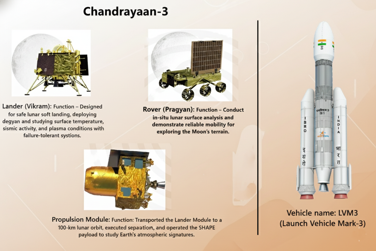
RAMBHA-LP
Measures **plasma density** near the lunar surface, helping understand how sunlight and solar wind affect the Moon.
ChaSTE
Studies **thermal properties** of the lunar soil by checking temperature variations at different depths.
ILSA
Measures **seismic activity** (moonquakes), providing data on the internal structure of the Moon.
APXS
Determines elements like **aluminium, sulphur, calcium, and iron** in lunar soil—useful for understanding lunar formation.
LIBS
Uses **laser pulses** to vaporize soil particles and accurately identify their elemental chemical composition.
Chandrayaan-3 launched in **July 2023** and entered lunar orbit after a series of Earth-bound maneuvers.
On **23 August 2023**, Vikram successfully landed near the **south polar region**, making India the first country to achieve a soft landing in this area.
Technological Demonstration
The **Lander touched down safely** and the **Rover successfully deployed and completed its experiments**, fulfilling the primary technology demonstration objectives.
Scientific Achievement
Instruments transmitted clear **temperature profiles and chemical signatures**, confirming the mission's scientific investigation goals were achieved.
**South Pole Exploration**: The landing helps in the search for **water ice**, which is crucial for potential future lunar habitats and resource utilization.
**Global Space Status**: It enhances India’s status as a **reliable spacefaring nation** and strengthens indigenous technologies needed for human spaceflight and deep space missions.
**Scientific Data**: Provides critical data for **planetary science** and informs ISRO’s upcoming missions like Lunar Sample Return concepts.
Mangalyaan
Mangalyaan (Mars Orbiter Mission – MOM)
Mangalyaan, launched by ISRO in **November 2013**, was India’s first interplanetary mission aimed at orbiting **Mars** and studying its surface, atmosphere, and mineral composition. It showcased India’s ability to conduct deep-space exploration using **cost-effective engineering**.
Technological Demonstration
The mission intended to demonstrate India’s capability to launch, navigate, and position a spacecraft around **Mars**.
Scientific Study
It aimed to study Martian atmospheric processes, surface features, and **methane traces**—considered indicators of past or existing life-supporting conditions.
ISRO used the **Polar Satellite Launch Vehicle (PSLV-C25)** for Mangalyaan. PSLV’s reliability, proven through multiple successful missions, allowed India to send a spacecraft beyond Earth’s gravitational influence without using a heavy-lift launch vehicle.
Reliability & Cost
PSLV was selected due to its **consistent track record** and **cost efficiency** for lighter payloads.
Trans-Mars Trajectory
ISRO used **multiple orbit-raising manoeuvres** to gradually push the spacecraft into a trans-Mars trajectory, compensating for PSLV's limited deep-space capability.
Design Strategy
The spacecraft used a **"modular design,"** reusing proven technology from Chandrayaan-1, which significantly **reduced cost and risk**.
Power and Control
MOM relied on **solar power** and carried **onboard autonomy** to handle long-distance communication delays inherent in deep-space missions.
Mars Colour Camera (MCC)
Captured **high-quality images** of the Martian surface and atmosphere.
Methane Sensor for Mars (MSM)
Checked for the presence of **methane**, a key biomarker for life.
Thermal Infrared Imaging Spectrometer (TIS)
Studied **thermal emissions** and composition of the Martian surface.
Mars Exospheric Neutral Composition Analyser (MENCA)
Observed the composition of the **upper Martian atmosphere**.
Lyman Alpha Photometer (LAP)
Measured **hydrogen loss** from Mars' exosphere, contributing to atmospheric evolution studies.
Atmospheric Studies
Provided detailed images of Martian **dust storms**, atmospheric escape, and **seasonal variations**.
Surface Features & Methane
Captured images of surface features like **craters and valleys**. Its methane data helped refine global models, even with **no significant detection**.
Asian First
Mangalyaan made India the **first Asian country** to successfully reach Mars orbit.
Maiden Attempt Success
It was the **first country in the world** to achieve Mars orbit on its maiden attempt.
Extended Lifespan
The spacecraft operated for nearly **8 years**—significantly surpassing its planned 6-month mission duration.
The mission famously cost around **₹450 crore**, making it one of the **world’s least expensive Mars missions**. This was achieved through smart design, utilizing the PSLV, a lighter payload, and prioritizing indigenous technologies.
Deep-Space Mastery
The mission boosted India’s capabilities in **long-distance communication**, deep-space navigation, and interplanetary mission planning.
Future Missions
The advancements are vital for future ISRO missions, including **Mars Orbiter Mission-2** and the Venus mission.
Global Standing
Mangalyaan elevated India’s **global scientific standing** and showed that developing nations can achieve complex space goals at low cost.
Inspiration
The mission strengthened India’s international collaborations and inspired **large-scale public interest** in space science.
Mangalyaan remains a **landmark** in India’s space journey. Through **cost-effective engineering**, scientific achievements, and technological progress, it set the foundation for India’s future planetary exploration and positioned **ISRO** among the world’s leading space agencies.
Aditya-L1
Aditya-L1 Mission
Aditya-L1 is **India’s first dedicated solar observatory mission**, launched by ISRO to study the Sun from the strategic **Lagrange Point L1**. This position offers continuous, uninterrupted views of the Sun without Earth’s shadow interference.
Objective of the Mission
The mission aims to understand how the **Sun behaves**, why it emits solar storms, and how these disturbances affect Earth. It helps scientists predict **space weather**, which is crucial for protecting satellites, communication networks, and power grids.
Why Lagrange Point L1?
L1 is a **gravitationally balanced point** about **1.5 million km** from Earth. A spacecraft here stays in stable alignment with the Sun, allowing **constant observation** of solar activity—like keeping a CCTV camera fixed on the Sun 24×7.
Launch Vehicle Used
Aditya-L1 was launched aboard **PSLV-XL**, a powerful variant of the Polar Satellite Launch Vehicle. PSLV-XL uses extended solid boosters that provide the thrust needed for **deep-space missions** beyond Earth’s orbit.
Development Journey
The project evolved from **Aditya-1** (a planned low-Earth-orbit mission) to Aditya-L1 after scientists realized the need for uninterrupted sunlight observation. Years of instrument development and collaboration with Indian research institutes shaped the upgraded mission.
VELC (Visible Emission Line Coronagraph)
Studies the **solar corona** (outermost layer) and the mechanism of its heating.
SUIT (Solar Ultraviolet Imaging Telescope)
Observes the Sun’s **photosphere** (surface) and **chromosphere** in the near-ultraviolet range.
SoLEXS (Solar Low Energy X-ray Spectrometer)
Measures the **soft X-ray emissions** from the Sun for studying solar flares.
HEL1OS (High Energy L1 Orbiting X-ray Spectrometer)
Detects high-energy **X-ray flares** and energetic particles near the L1 point.
Magnetometer (MAG)
Measures the precise **interplanetary magnetic fields** around the L1 point.
PAPA (Aditya Solar Wind Particle Experiment)
Studies the composition and energy distribution of the **solar wind** and its particle flow.
High Energy L1 Detector (ARIES)
Monitors the flux of **high-energy particles** that are accelerated during solar explosive events.
The instruments capture **images, radiation signatures, and particle data**. For example, VELC tracks coronal loops and eruptions, while SUIT measures ultraviolet light to understand **solar temperature variations**.
Success of the Mission
Aditya-L1 **successfully reached its halo orbit** around L1 after a four-month journey. All payloads were activated in stages, and early results have already shown clear images of the solar disk and detailed **coronal structures**.
Significance for Science
By studying the Sun’s upper layers, Aditya-L1 helps explain long-standing mysteries like **coronal heating**. It also improves global scientific understanding of solar physics and **complements missions by NASA and ESA**.
Significance for India
The mission strengthens **India’s position in space research**, boosts **indigenous instrumentation**, and trains a new generation of solar physicists. It showcases India’s capability to undertake complex deep-space missions.
Benefits for Daily Life
Better **solar weather prediction** protects satellites, GPS signals, aviation routes, and power grids. This is especially useful for India’s growing digital economy, which depends heavily on **space-based services**.
Indian Space Research Organisation
Indian Space Research Organisation (ISRO)
The **Indian Space Research Organisation (ISRO)** is India's national space agency responsible for developing space technology and applying it for national development. Established in **1969**, ISRO focuses on affordable, reliable, and innovation-driven space missions that support communication, navigation, earth observation, and scientific exploration.
Controlling Ministry and Department
ISRO functions under the **Department of Space (DoS)**, which directly reports to the **Prime Minister of India**. This unique administrative structure ensures strategic decision-making, faster approval of missions, and seamless coordination for national-level space programmes and international collaborations.
Headquarters
ISRO's headquarters is located in **Bengaluru, Karnataka**. The city hosts multiple research centres, making it a major hub for satellite development, mission design, propulsion research, and software innovation required for India's growing space capabilities.
Objectives
ISRO’s primary objective is to harness space technology for **socio-economic development**. It aims to strengthen satellite-based communication, remote sensing, navigation, and meteorology. ISRO also focuses on advancing scientific research, improving disaster management, and expanding India's presence in global space exploration.
Assigned Tasks
ISRO develops **satellites, launch vehicles, ground systems**, and **interplanetary missions**. Tasks include creating cost-effective launch systems like **PSLV and GSLV**, providing space-based services, enabling GPS-like navigation via **NavIC**, and promoting private sector participation through **IN-SPACe** reforms.
Major Missions
Recent achievements include **Chandrayaan-3’s** successful lunar landing, **Aditya-L1** solar observatory mission, and improved **NavIC** satellite upgrades for enhanced indigenous navigation services.
Future Programmes
ISRO is also progressing on **Gaganyaan**, India’s first human spaceflight programme, along with reusable launch vehicle trials for future low-cost and **sustainable space missions**.
Antrix Corporation Limited
Antrix Corporation Limited
Antrix Corporation Limited is the **commercial arm** of the Indian Space Research Organisation (ISRO). It was established in **1992** to market Indian space products, services, and technologies **globally**. Antrix acts as a bridge between ISRO’s capabilities and international commercial demands.
Reporting Structure
Antrix operates under the **Department of Space (DoS)**, which functions directly under the **Prime Minister**. This structure enables faster decision-making and alignment with India’s broader strategic and technological goals.
Headquarters
Antrix is headquartered in **Bengaluru, Karnataka**, close to ISRO’s main research centres. Its location supports better coordination with ISRO facilities involved in satellites, launch vehicles, and communication services.
Commercialization of Technology
A key objective of Antrix is to **commercialize space technology** developed in India. This includes selling **satellite data**, launching **foreign satellites**, providing **communication transponder services**, and supporting global remote-sensing needs.
Promotion of Private Sector
It also works to **promote Indian space manufacturing**, encouraging private firms to supply components for satellites and launch systems. For example, Antrix facilitates agreements for **small-satellite launches** using PSLV rockets.
Global Market Foothold
Antrix helps India gain a foothold in the **global space market** by offering reliable and **cost-effective launch services**. It showcases ISRO's dependable technology, helping India compete with agencies like ESA and SpaceX in select segments.
Showcasing ISRO’s Capability
By securing contracts and successfully executing commercial missions, Antrix has played a crucial role in building the **international reputation** of ISRO as a capable and trusted space agency.
Shift in Commercial Responsibilities
In recent years, Antrix’s commercial responsibilities have **reduced** as newer bodies like **NewSpace India Limited (NSIL)** took over major commercial operations. Antrix now focuses on contract management, tech marketing, and **legacy service commitments**.
Current Focus Areas
Its focus now includes supporting **satellite communication services** and handling **long-term agreements** signed before NSIL’s creation, ensuring continuity of services to existing national and international clients.
New Space India Limited
New Space India Limited (NSIL)
Overview
New Space India Limited (NSIL) is a central public sector enterprise under the Indian Space Research Organisation (ISRO). It was created to **commercialise India’s space technologies, launch services, and satellite products** for global and domestic markets.
Headquarters
The headquarters of NSIL is located in **Bengaluru, Karnataka**, allowing close coordination with ISRO centres such as URSC, SDSC-SHAR, and ISTRAC, which support satellite development, launch operations, and mission management.
Controlling Ministry and Department
NSIL operates under the **Department of Space (DoS)**, which functions directly under the **Prime Minister’s Office**. This structure ensures quick decision-making and alignment with India’s long-term space vision.
Commercial Arm of ISRO
NSIL aims to act as the **commercial arm of India’s space programme**. Its key goal is to transfer ISRO-developed technologies to private industries and expand India’s participation in the global space economy.
Technology Transfer Role
A major responsibility of NSIL is enabling Indian companies to adopt ISRO technologies. It handles licensing and production-scale transfer, ensuring industries can build **reliable satellite components** and space-grade materials.
Launch Vehicle Promotion
One of the primary objectives is to **promote Indian launch vehicles** (like PSLV and GSLV) globally and domestically, securing commercial contracts for launch services and positioning India as a key player in the space transport market.
Industry-Led Manufacturing
The government has authorised NSIL to **manufacture, assemble, and integrate launch vehicles through industry**. This shifts production responsibility from ISRO to private Indian players.
Demand-Driven Satellite Missions
NSIL undertakes satellite missions on a **demand-driven model**, meaning satellites are built and launched based on specific customer needs, rather than government directives for strategic purposes.
Launch and Communication Services
NSIL provides **launch services using PSLV and GSLV rockets**, leases transponders for communication services, and markets ISRO’s small satellite platforms to global and domestic customers.
Successful Commercial Launches
NSIL has successfully placed **multiple foreign satellites in orbit** through PSLV missions. For example, NSIL helps foreign companies launch small Earth-observation satellites using PSLV.
Commercial Satellite Deliveries
It has completed major demand-driven satellites, such as **GSAT-24, for commercial customers**. These projects demonstrate the success of the new market-oriented approach.
Global Collaboration
NSIL is actively expanding collaboration with global operators and space agencies to **boost India’s space export potential** and capture a larger share of the international space market.
IN-SPACe
IN-SPACe: Indian National Space Promotion and Authorization Centre
Autonomous Nodal Agency
IN-SPACe is an **autonomous nodal agency** created by the Government of India to **regulate, promote, and authorize private sector participation** in the space sector. It acts as a link between **ISRO** and private players, ensuring balanced access to space resources.
Department of Space (DoS)
IN-SPACe functions under the **Department of Space (DoS)**, which comes directly under the **Prime Minister’s Office (PMO)**. This structure ensures high-level policy coordination and quicker decision-making for India’s expanding space ecosystem.
Ahmedabad, Gujarat
The headquarters of IN-SPACe is located in **Ahmedabad, Gujarat**. It also plans regional technical centres to support private industries with testing, launch, and mission-readiness capabilities.
Foster Private Ecosystem
The main objective is to create a **healthy environment for private space companies** in India, encouraging innovation and reducing dependence on ISRO for non-strategic activities.
Streamline Approvals
It aims to **streamline approvals**, provide **transparent regulations**, and ensure fair access to facilities for private players seeking to operate in the space domain.
Evaluate Proposals
IN-SPACe **evaluates private proposals** for satellites, launch vehicles, space-based services, and R&D missions before authorization.
Allocate ISRO Facilities
It **allocates ISRO facilities**—such as launch pads, tracking systems, and test centres—to private firms on fair and equitable terms.
Compliance and Dispute Resolution
It also resolves technical disputes, ensures **safety compliance**, and manages the use of orbital slots and radio-frequency spectrum.
Commercial Strength and Applications
The agency helps convert India’s strong space capability into **commercial strength**. By supporting startups and industries, IN-SPACe **boosts satellite manufacturing, small-launch vehicle development**, and Earth-observation applications like **weather services and disaster response**.
Private Launch Missions
Recent steps include **authorization of private launch missions**, providing private sector a role in launch and space operations.
Access to ISRO Facilities
Facilitated private access to **ISRO’s propulsion and testing facilities**, reducing the time and cost for R&D and manufacturing.
Global Market Integration
IN-SPACe is guiding India’s emerging space-tech startups to participate in **global markets** and implement the new **Space Policy 2023** initiatives.
Project NETRA
Project NETRA - ISRO
Introduction
Project **NETRA (Network for Space Object Tracking and Analysis)** is **ISRO’s initiative** to monitor **space debris** and protect Indian satellites. It builds a network of telescopes, radars, data-processing units, and control centres to **track objects in Earth’s orbit**.
Detection and Protection
Project NETRA aims to **detect, track, and predict** the movement of **space debris**, especially pieces above 10 cm. It helps ISRO assess **collision risks**, issue alerts, and execute timely **manoeuvres** to safeguard operational satellites.
Strategic Importance
Space debris is increasing rapidly due to satellite crowding, defunct spacecraft, and breakup events. Even tiny fragments can damage satellites because of high velocity. NETRA provides India an **independent mechanism for space situational awareness**, reducing reliance on foreign tracking data.
Functioning (Simple Example)
If two satellites appear to pass close in orbit, NETRA’s sensors calculate their exact paths. If collision probability rises, ISRO can **adjust its satellite’s position slightly**—similar to changing lanes to avoid an accident.
Core Components
It includes **long-range telescopes, multi-object tracking radars, laser ranging systems**, and a dedicated control centre. Together, these components allow continuous surveillance of **Low Earth Orbit (LEO)** and **Geostationary Orbit (GEO)**.
Latest Enhancements
ISRO has set up new tracking facilities in **Bengaluru, Mount Abu, and Thiruvananthapuram**. A high-precision **Multi-Object Tracking Radar (MOTR)** and upcoming space surveillance telescopes are enhancing India’s debris-tracking accuracy and expanding coverage.
Gaganyaan Mission
Gaganyaan Mission
Gaganyaan is India’s first human spaceflight mission, designed to send a crew of three astronauts to a Low Earth Orbit (LEO) of about 400 km for three days and bring them back safely.
It marks India’s transition from robotic missions to a human-rated space capability, showcasing indigenous technological advancement.
The mission is led by ISRO with crucial support from DRDO, HAL, and multiple national agencies, emphasizing a collaborative national effort.
Indigenous Capability
The primary aim is to achieve indigenous human spaceflight capability, including crew training, developing life-support systems, a human-rated launch vehicle, and safe re-entry technology.
Long-Term Vision
A major goal is to strengthen India’s long-term vision for space exploration, which will enable future projects like establishing a space station and executing interplanetary missions.
Research and Development
It aims to boost advanced research and development in critical areas such as materials science, robotics, and the challenging field of space medicine.

Global Standing
Gaganyaan elevates India into a select group of nations—USA, Russia, and China—capable of human spaceflight, enhancing global scientific standing and opening doors for international collaborations.
Innovation & Inspiration
Domestically, it stimulates high-end innovation in AI, sensors, propulsion, and manufacturing. It also inspires STEM education, encouraging students to pursue space science and engineering.
HLVM3 (Human-rated LVM3)
This is the mission's dedicated, highly reliable launch vehicle, analogous to the engine and chassis that launches the spacecraft into orbit.
Crew Module (CM)
Functions like a protective capsule carrying astronauts, designed to withstand the harsh environment of space and the heat of atmospheric re-entry.
Service Module (SM)
Provides essential resources like power, thermal control, and propulsion—similar to how a car's engine and support systems sustain the vehicle during a trip.
Crew Escape System (CES)
Works like an emergency ejection seat, quickly pulling the Crew Module and astronauts away from the launch vehicle in case of a launch failure.
TV-D1 Test Flight
ISRO successfully conducted the TV-D1 Test Flight, which was crucial for validating the operation and performance of the crew escape system during an abort scenario.
Testing and Training
Multiple high-altitude abort tests and Crew Module atmospheric re-entry tests were completed. Astronauts underwent extensive training in both India and Russia.
Uncrewed Mission G1
The first uncrewed Gaganyaan mission (G1) is strategically scheduled before the final human mission to demonstrate the complete system performance and reliability.
Indian Data Relay Satellite System (IDRSS)
Concept and Function
The **Indian Data Relay Satellite System (IDRSS)** is a planned network of **Geostationary (GEO) communication satellites** positioned to provide **continuous, real-time linkages** between India's **Low-Earth-Orbit (LEO) satellites**, rockets, future space stations, and ground stations. It ensures uninterrupted data flow and control signals, crucial when spacecraft are not in the direct line-of-sight of Indian ground stations.
Near-Continuous Communication
The main goal is to support India’s growing space missions by enabling **near-continuous communication** with spacecraft, especially those in LEO, which currently experience communication blackouts due to Earth's curvature.
Human Spaceflight Support
It is vital for the **Gaganyaan mission** as it will provide an **uninterrupted, critical link** between the crew module and Mission Control, allowing constant health and safety monitoring for the astronauts.
Enhanced Deep Space and EO Monitoring
The system will boost launch vehicle tracking, support complex deep-space missions, and enable **high-data-rate communication** for next-generation Earth Observation (EO) satellites, making overall mission management faster and more reliable.
Ensures Continuous Coverage
Currently, satellites over remote areas suffer communication loss due to Earth's curvature. IDRSS solves this by having GEO satellites relay signals, providing **seamless, 24x7 communication coverage** for LEO missions, similar to the US TDRS system.
Crucial for Gaganyaan
For India's first human spaceflight, IDRSS is a **mandatory requirement**. It provides the **uninterrupted, critical data uplink and downlink** needed for constant monitoring of the crew's vital signs and the space capsule's systems, ensuring crew safety.
Boosts Launch Vehicle Tracking
Relay satellites ensure that even during the most critical phases of rocket ascent, when ground stations might lose line-of-sight, **continuous telemetry data** is received. This improves safety, accuracy, and real-time decision-making during launches.
Enhances Earth Observation Missions
High-resolution remote-sensing satellites generate massive amounts of continuous data. IDRSS allows for **quicker data relay** back to Earth, which is essential for rapid-response applications like **disaster management** and real-time weather monitoring.
Initial Satellites and Orbit
ISRO is actively developing the two initial satellites, **IDRSS-1 and IDRSS-2**, which are planned to be placed in a **Geostationary Earth Orbit (GEO)** at approximately 36,000 km altitude to provide wide coverage over the Indian subcontinent.
Mission Support Focus
These relay satellites will specifically support the **Gaganyaan manned mission**, future space docking experiments, crew capsule recovery tests, and facilitate high-bandwidth data needs for new-generation Earth-observation missions.
Ground Infrastructure
Alongside satellite development, India is upgrading its existing ground infrastructure and testing facilities to seamlessly integrate IDRSS, ensuring a robust and reliable system for upcoming high-stakes space endeavors.
India’s Space Policy and Global Share
Indian Space Policy 2023
The Indian Space Policy 2023 aims to expand India’s space sector by enabling greater private participation, defining roles of ISRO, IN-SPACe and NSIL, encouraging innovation, and boosting India’s presence in the global space economy.
Private Sector Participation
The policy allows Non-Governmental Entities (NGEs) to engage in end-to-end space activities, such as building satellites and launch vehicles, and commercializing data, marking a major shift.
Role of ISRO
The Indian Space Research Organisation (ISRO) will shift focus to advanced research and development and cutting-edge space technology, stepping back from routine operational missions.
Role of IN-SPACe
The Indian National Space Promotion & Authorisation Centre (IN-SPACe) is designated to **authorize space activities** for all entities and promote the growth of the private sector and academia.
Role of NSIL
NewSpace India Limited (NSIL) will be responsible for commercializing space technologies and services developed by ISRO, acting as the public sector undertaking.
Enhanced R&D and Education
The policy emphasizes nurturing space education and research to build a skilled workforce and invest in advanced technologies for future missions and industry needs.
Space Ecosystem Development
It aims to create a stable regulatory framework and a level playing field for private players to drive growth, innovation, and self-reliance in the space economy.
International Cooperation
The policy seeks to strengthen India's position through **international cooperation** and **knowledge sharing**, aligning national efforts with global standards and partnerships.
Data Access Regulations
It provides for **open access to satellite data** with a ground sample distance (**GSD**) **greater than five meters**, while requiring authorization for higher-resolution data for national security reasons.
Current Share
India holds about 2% of the global space economy, which was valued at approximately $8.4 billion as of 2022. This is set to rapidly change with the new policy.
Projected Growth
The Indian space economy is projected to grow fivefold to $44 billion by 2033. This growth is expected to increase India's share of the global market to around 8% by 2033, potentially reaching 15% by 2047.
Private Sector Involvement
Reforms in 2020 have encouraged private participation in areas like satellite design, launch, and ground station services, with over 189 space startups active in 2023.
Downstream Services Focus
A strong focus on monetizing **downstream services** like satellite communication, navigation, and Earth observation is a major growth driver for the economy.
Facilitating Role of ISRO/IN-SPACe
ISRO is facilitating private sector growth through technology transfer, and regulatory bodies like IN-SPACe are ensuring a smooth transition and operational ease for startups.
Strategic Government Initiatives
The government is supporting the sector through initiatives like a ₹1000 crore venture capital fund, aimed at fostering innovation and funding early-stage space startups.
No comments:
Post a Comment